In 2004, the Colorado Trail celebrated their 30th anniversary. It was the regional forrester, Bill Lucas, who gave a talk to the Colorado Mountain Club on November 3, 1970. Lucas proposed a hiking trail from Denver to Durango, calling it The Rocky Mountain Trail. The plan for the Trail was launched in 1974, with a goal to develop a non-vehicular trail system, with the Roicky Mountain Trail serving as the backbone. The Colorado Trail Takes Shape in Colorado Magazine. At that time, the activity of backpacking was in it’s infancy, when most equipment was imported from Europe. Today, there is a Colorado Trail Foundation, Wilderness Areas, and ever growing use of the outdoors as part of an active lifestyle.
Our trail guide uses the Trail Widgets from thehikingproject.com to support hikers in planning for the Trail.
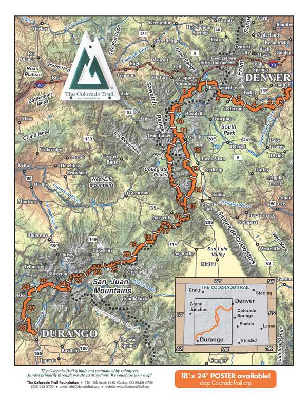
The Trail is broken up into 28 segments with access points for each section. Thru hikers should plan for a four to six week journey for the complete trail.
The Colorado Trail Hiker App- Adnroid
Colorado Trail Hiker App-Itunes
The Colorado Trail Hiker is a smartphone guide for your Colorado Trail hiking or mountain biking trip. The free demo is a fully functional version of the app with Segment 1 of The Colorado Trail (Miles 0 to 16.8 from the Waterton Canyon Trailhead outside Denver). In-app purchases include (1) The Colorado Trail, which includes the hiking route, the five mountain bike wilderness detours, the Collegiate West Alternative route and the Collegiate Loop (775.2 miles of trail in total) and (2) a standalone version of the Collegiate Loop route (a 160.4-mile loop composed of the 82.3-mile Collegiate West Alternative route and a 78.1-mile portion of The Colorado Trail).”
]]>Distance: 25.4 miles
Elevation Gain: 4,417 feet
Ranger District:
Dillon RD, White River NF
680 Blue River Parkway
Silverthorn
(970) 468-5400
Holy Cross RD, White River NF
24747 Hwy 24
Minturn
(970) 827-5715
Section 9: Tennessee Pass TH to Timberline Lake TH
Distance: 13.6 miles
Elevation Gain: 2.627 feet
Ranger District:
Leadville RD, San Isabel NF
810 Front Street
Leadville
(719) 486-0749
Section 10: Timberline Lake TH to Mount Massive TH
Distance: 13.1 miles
Elevation Gain: 2,690 feet
Ranger District:
Leadville RD, San Isabel NF
810 Front Street
Leadville
(719) 486-0749
Section 11: Mount Massive TH to Clear Creek Road
Distance: 21.5 miles
Elevation Gain: 2,910 feet
Ranger District:
Leadville RD, San Isabel NF
810 Front Street
Leadville(719) 486-0749
Section 12: Clear Creek Road to Silver Creek TH
Distance: 18.5 miles
Elevation Gain: 4,866 feet
Ranger District:
Leadville RD, San Isabel NF
810 Front Street
Leadville
(719) 486-0749
Section 13: Silver CreekTH to Chalk Creek TH
Distance: 22.8 miles
Elevation Gain: 4,296 feet
Ranger District:
Salida RD, San Isabel NF
5575 Cleora Road
Salida
(719) 539-3591
Section 14: Chalk Creek TH to US 50
Distance: 20.4 miles
Elevation Gain: 4,007 feet
Ranger District:
Salida RD, San Isabel NF
5575 Cleora Road
Salida
(719) 539-3591
Distance: 14.3 miles
Elevation Gain: 3,576 feet
Ranger District:
Salida RD, San Isabel NF
5575 Cleora Road
Salida
(719) 539-3591
Gunnison RD, GMUG NF
2250 Highway 50
Delta
(970) 874-6660
Section 16: Marshall Pass TH to Sargents Mesa
Distance: 15.2 miles
Elevation Gain: 3,184 feet
Ranger District:
Salida RD, San Isabel NF
5575 Cleora Road
Salida
(719) 539-3591
Gunnison RD, GMUG NF
2250 Highway 50
Delta
(970) 874-6660
Saguache RD, Rio Grande NF
46525 Hwy 114
Saguache
(719) 655-2547
Section 17: Sargents Mesa to Colorado HWY 114
Distance: 20.4 miles
Elevation Gain: 2,810 feet
Ranger District:
Gunnison RD, GMUG NF
2250 Highway 50
Delta
(970) 874-6660
Saguache RD, Rio Grande NF
46525 Hwy 114
Saguache
(719) 655-2547
Section 18: Colorado HWY 114 to Saguache Park Road
Distance: 13.8 miles
Elevation Gain: 1,447 feet
Ranger District:
Gunnison RD, GMUG NF
2250 Highway 50
Delta
(970) 874-6660
Section 19: Saguache Park Road to Eddiesville TH
Distance: 13.7 miles
Elevation Gain: 2,239 feet
Ranger District:
Gunnison RD, GMUG NF
2250 Highway 50
Delta
(970) 874-6660
Section 20: Eddiesville TH to San Luis Pass
Distance: 12.7 miles
Elevation Gain: 3,104 feet
Ranger District:
Gunnison RD, GMUG NF
2250 Highway 50
Delta
(970) 874-6660
Section 21: San Luis Pas to Spring Creek TH
Distance: 14.9 miles
Elevation Gain: 3,116 feet
Ranger District:
Gunnison RD, GMUG NF
2250 Highway 50
Delta
(970) 874-6660
Divide RD, Rio Grande NF
13308 West Hwy 160
Del Norte
(719) 657-3321
Distance: 17.2 miles
Elevation Gain: 3,829 feet
Ranger District:
Gunnison RD, GMUG NF
216 North Colorado
Gunnison
(970) 641-0471
Divide RD, Rio Grande NF
13308 West Hwy 160
Del Norte
(719) 657-3321
Section 23: Carson Saddle to Stony Pass TH
Distance: 15.9 miles
Elevation Gain: 3,515 feet
Ranger District:
Gunnison RD, GMUG NF
216 North Colorado
Gunnison
(970) 641-0471
Divide RD, Rio Grande NF
13308 West Hwy 160
Del Norte
(719) 657-3321
Section 24: Stony Pass TH to Molas Pass
Distance: 20.2 miles
Elevation Gain: 3,475 feet
Ranger District:
Divide RD, Rio Grande NF
13308 West Hwy 160
Del Norte
(719) 657-3321
Columbine RD, San Juan NF
367 Perl Street
Bayfield
(970) 884-2512
Section 25: Molas Pass to Bolam Pass Road
Distance: 20.9 miles
Elevation Gain: 3,779 feet
Ranger District:
Columbine RD, San Juan NF
367 Perl Street
Bayfield
(970) 884-2512
Dolores RD
29211 Hwy 184
Dolores
(970) 882-7296
Section 26: Bolam Pass Road to Hotel Draw Road
Distance: 10.9 miles
Elevation Gain: 1,827 feet
Ranger District:
Columbine RD, San Juan NF
367 Perl Street
Bayfield
(970) 884-2512
Section 27: Hotel Draw Road to Kennebec TH
Distance: 20.6 miles
Elevation Gain: 4,186 feet
Ranger District:
Columbine RD, San Juan NF
367 Perl Street
Bayfield
(970) 884-2512
Section 28: Kennebec TH to Junction Creek TH
Distance: 21.5 miles
Elevation Gain: 1,897 feet
Ranger District:
Columbine RD, San Juan NF
367 Perl Street
Bayfield
(970) 884-2512
Waterton Canyon Recreation Map
Denver Water Information Link : Waterton Canyon
Waterton Canyon: Colorado Trail.org
If your plans include leaving a vehicle in Waterton Canyon, consult both the Trail.org and Denver Water websites for additional information.
Section 1: Waterton Canyon TH to South Platt River TH
Distance: 16.8 Miles
Elevation Gain: 2,830 feet
Ranger District:
South Platte RD, Pike NF
19316 Goddard Ranch Court
Morrison
(303) 275-5610
Section 2: South Platte TH to Little Scraggy TH
Distance: 11.5 miles
Elevation Gain: 2,482 feet
Ranger District:
South Platte RD
19316 Goddard Ranch Court
Morrison
(303) 275-5610
Section 3: Little Scraggy TH to FS-560 (Wellington Lake) TH
Distance: 12.2 miles
Elevation Gain: 1,975 feet
Ranger District:
South Platte RD
19316 Goddard Ranch Court
Morrison
(303) 275-5610
Section 4: FS-560 (Wellington Lake) TH to Long Gulch
Distance: 16.6 miles
Elevation Gain: 3,271 feet
Ranger District:
South Platte RD
19316 Goddard Ranch Court
Morrison
(303) 275-5610
South Park RD
320 Hwy 285
Fairplay
(719) 836-2031
Section 5: Long Gulch to Kenosha Pass
Distance: 14.6 miles
Elevation Gain: 1,858 feet
Ranger District:
South Platte RD
19316 Goddard Ranch Court
Morrison
(303) 275-5610
South Park RD
320 Hwy 285
Fairplay
(719) 836-2031
Section 6: Kenosha Pass to Goldhill TH
Distance: 32.9 miles
Elevation Gain: 5,196 feet
Ranger District:
Dillon RD, White NF
680 Blue River Parkway
Silverthorn
(970) 468-5434
Section 7: Goldhill TH to Copper Mountain
Distance: 12.8 miles
Elevation Gain: 3,674
Ranger District:
Dillon RD, White River NF
680 Blue River Parkway
Silverthorn
(970) 468-5434