Deprecated: Function get_magic_quotes_gpc() is deprecated in /home5/jnelson/westerncooutdoors.com/wp-content/plugins/wpml-string-translation/inc/functions.php on line 15

Warning: Cannot modify header information - headers already sent by (output started at /home5/jnelson/westerncooutdoors.com/wp-content/plugins/wpml-string-translation/inc/functions.php:15) in /home5/jnelson/westerncooutdoors.com/wp-includes/feed-rss2.php on line 8
ride | Western Colorado Outdoors https://westerncooutdoors.com Your Guide to Outdoor Adventure on the Western Slope Sun, 26 Aug 2018 12:56:06 +0000 en-US hourly 1 https://wordpress.org/?v=6.5.3 https://westerncooutdoors.com/wp-content/uploads/2019/05/cropped-WCO-Favacon-32x32.png ride | Western Colorado Outdoors https://westerncooutdoors.com 32 32 Ridgway Area Trails https://westerncooutdoors.com/?p=6947 Wed, 03 Jan 2018 20:01:31 +0000 https://westerncooutdoors.com/archives/6947 Read More]]> Ridgway Area Trails are located south of Montrose off of Highway 550. The foundation of the Ridgeway Area Trails is the RAT Group. RAT has been dedicated to founding and supporting mountain bike trails in the Ridgway area. RAT is a local chapter of the Colorado Plateau Mountain Bike Trail Association, Inc.

Working with the town of Ridgway, Ouray County, the Bureau of Land Management and Colorado State lands, construction of the trail project started in 2011 with the goal of an initial construction of over 30 miles of trail. In 2013 and 2014 RAT has added approximately 8 miles of trail, between Ridgway town land and BLM managed land. Collaboration with the Colorado Parks and Wildlife enabled RAT to receive a $200,000 grant for additional trail construction. Continuing collaboration with COPMOBA (Colorado Plateau Mountain Bike Trail Association, Inc.) and Colorado Parks and Wildlife supported additional construction of 7.5 additional miles of trail in 2016.

Come and celebrate the Ridgway Area Trails, support RAT and COPMOBA!

Basecamp Ouray Link

[wunderground location=”Ridgway, CO” numdays=”4″ layout=”simple”]

Ridgway Area Trails

(Ridgway State Park)


RAT Trails

(Ridgway State Park)


Speedy Gonzales

(Ridgway State Park)


Rat Trap

(Ridgway State Park)


The Big Cheese

(Ridgway State Park)


Rattus Maximus

(Ridgway State Park)


Rattus Maximus Spur

(Ridgway State Park)


Dennis Weaver Memorial Park

(Dennis Weaver Memorial Park)


]]>
Ride: Shavanao Valley https://westerncooutdoors.com/?p=5966 https://westerncooutdoors.com/?p=5966#respond Thu, 16 Nov 2017 15:42:23 +0000 https://westerncooutdoors.com?p=5966 Read More]]> This grouping of mountain bike trails is the southern anchor for the Tabeguache Trail. trail head about 9 miles from downtown Montrose to the No Thoroughfare Canyon at the Colorado National Monument just outside of Grand Junction. The trail is over 140 miles in length and takes several days to complete.

Shavano Valley is located west of Montrose on the other side of Spring Creek Mesa. Driving on West Main Street, continue west with the street as it turns into Spring Creek Boulevard. Continue on Spring Creek until 5875 Road, at the junction drive right (north) on 5875 Road until reaching Kiowa Road (the first left road), continue across the Shavanao Valley to the junction with Shavano Valley Road, turning left drive south until shortly meeting the Rim Road junction. Parking is found on the south side of Rim Road.

Dry Creek Road


Fenceline Loop (Porkchop):

Cushman Creek Trail:


Cowpoke Gulch Road:


Cushman Mesa Road:


Toldja Loop:


The Fingers:


Tabeguache Trail – Dry Creek Section:


Ewok Village:

Coyote Cutoff:


Ewok Village North Cutoff:


Tabeguache Trail – Transfer Road Section:


Dry Creek Canyon Trails


]]>
https://westerncooutdoors.com/?feed=rss2&p=5966 0
Ride the West End https://westerncooutdoors.com/?p=5928 Tue, 14 Nov 2017 19:03:00 +0000 https://westerncooutdoors.com?p=5928 Read More]]> When thinking of the West End, the words wild and scenic come to mind. West End Mountain Biking features high mesas, deep sandstone canyons, and arroyos. Views of the LaSalle Mountains just over the state line in Utah, as well as the Northern San Juans predominate. Exploring large tracts of pristine public lands on hundreds of miles of double and single track give the rider endless options for exploration. Being the high desert, caution must be taken, carry lots of water and be prepared with water filtration. Animal sightings are common, including elk, deer, bear, coyote, mountain lion, and bobcat.

Paradox Trail:


Cutler Rim Trail:


Y-11 Loop or Out N’ Back:


Lumsden Loop:


Y-11 Trail:


Wildflower Trail – South:


Red Canyon Loop:


Blue Mesa Trail:


Gateway Trails Tour:


Pinon Point Loop:


Note: Trail Widget is incorrect, this trail is located near Norwood, not Mountain Village.

]]>
Ride Palisade https://westerncooutdoors.com/?p=5265 Fri, 13 Oct 2017 17:34:30 +0000 https://westerncooutdoors.com?p=5265 Read More]]> The Palisade Rim Trail explores the southern rim of Palisade. The Palisade Rim Trail garners the majority of biking attention in Palisade, With almost 1,500 feet of ascent and descent this trail is not for the novice biker. The trail passes close to cliff edges, caution is the word, as this trail is also open to hiking and horseback riding.

The Palisade Plunge Trail, from the top of Grand Mesa down to the town of Palisade, is currently in the planning phase. This proposed 30 mile trail would be open to mountain bikes and hiking. The following link gives the reader an update to the latest developments.

Palisade Rim:
Watch for hikers!


Mountain biking the new Palisade Rim Trail from Jason Blevins on Vimeo.

]]>
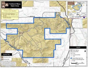
Ride: Rifle-Hubbard Mesa https://westerncooutdoors.com/?p=3694 Tue, 04 Jul 2017 17:55:25 +0000 https://westerncooutdoors.com/?p=3694/ Read More]]> The Hubbard Mesa Area, northwest of Rifle consists of 2,480 acres with 50 miles of single track, ATV, and jeep trails. Hubbard Mesa can be accessed from the Highway 13 Bypass. Turn north onto County Road 244 (Fravert Reservoir Road) where the Rifle District Forest Service office is located. After two miles turn right at the fork onto County Road 290. Continue for approximately 1 mile to the parking area and the trailhead.


Hubbard Mesa Trail Area pdf

Basecamp Rifle Link


Rifle Area Trails


Roan Cliff Chaos:


Lower Faceplant:


Faceplant:


Rusty Shovel:


Mighty McLeod:


Whiskey Tango Express:


Doubletrack – BLM Lot to Gun Loop:


]]>
Ride: Canyons of the Ancients https://westerncooutdoors.com/?p=1530 Fri, 24 Mar 2017 15:36:16 +0000 https://westerncooutdoors.com/?p=1530 Read More]]> The Canyons of the Ancients National Monument is located west of Coretz in the southwest corner of Coilorado. This national monument was created in 2000, consisting of 176,056 acres and managed by the Bureau of Land Management. Within the boundaries of this monument are three of the four sections of Hovenweep National Monument (National Park Service). The Monument was created to preserve the largest concentration of Ancestral Puebloan ruins in the United States.

Sand Canyon Trail

Saddle Horn Cliff Dwelling, Sand Canyon Trail

The Sand Canyon Trail has 8 significant cliff dwellings along the trail and the major trail from the lower trail head.


Basecamp Cortez Link


Canyons of the Ancients Loop


East Rock Creek Trail


Dolores Area Rides (North of the National Monument):

Olympique Loop


Mavericks Trail


Italian Ice Loop – Winter


Crimson Slide Loop – Winter


Speedy’s Loop – Winter


Mavericks Trail


Italian Canyon Trail


Boggy Draw Loop


Bean Canyon Loop


]]>
Moab: Dead Horse Point https://westerncooutdoors.com/?p=308 Sat, 21 Jan 2017 22:17:58 +0000 https://westerncooutdoors.com/?p=308 Read More]]> Dead Horse Point sits about 2,000 feet above a gooseneck in the Colorado River. The Dead Horse Point State Park is nine miles northwest of Moab on US 191 and then 23 miles southwest on Utah 313 to the end of the highway. Opened to the public as a state park in 1959, with an elevation: 5,900 feet. Local lore tells of cowboys rounding up wild mustangs, herding them to the end of the point to corrral the horses. The name of the point comes from horses left in the corral that died due to the lack of water.

Basecamp Moab Link

Dead Horse Point Tour


Pair


Whiptail


Big Chief


Great Pyramid


Crossroads


Raven Roll


]]>
Moab: State Highway 191 South https://westerncooutdoors.com/?p=295 Sat, 21 Jan 2017 21:33:11 +0000 https://westerncooutdoors.com/?p=295 Basecamp Moab Link

Behind the Rocks Road


24-Hours of Moab


Hunter Canyon Rim


Hurrah Pass


Pritchett Canyon


HyMasa/Captain Ahab Huckfest


Amasa Back / Cliffhanger


Jacksons


Jackson Hole


Captain Ahab


Jacobs (Jacksons) Ladder


Rockstacker


Pothole Arch


Lockhart Basin


Lockhart Canyon


]]>
Moab: Navajo Rocks Area https://westerncooutdoors.com/?p=275 Sat, 21 Jan 2017 19:50:42 +0000 https://westerncooutdoors.com/?p=275 Read More]]> Moab: Navajo Rocks Area

The Navajo Rocks Riding Area is about 10 miles north of Moab off of State Highway 313. The first part of the trail system was completed by May 2013. The first trail head is 5 miles from State Highway 191 north.

Basecamp Moab Link

[wunderground location=”Moab, UT” numdays=”4″ layout=”simple”]

Navajo Rocks Chaco Loop


7-UP


Hey Joe – Spring Canyon Loop


Chisholm Trail


Whirlwind Loop


Hidalgo


Wildcat


Mustang Loop


7-Up Singletrack Option


Mag 7


Poison Spider


White Rim Trail


]]>
Moab https://westerncooutdoors.com/?p=266 Fri, 20 Jan 2017 19:49:08 +0000 https://westerncooutdoors.com/?p=266 Read More]]> Ride: Moab

Moab is the county seat of Grand County, Utah. Eastern Utah is the home to world class slick rock mountain biking. Prior to community settlement in the 1850’s by Latter-day Saints coming from the north, Moab was the main crossing point of the Colorado River on the Old Spanish Trail for traders, trappers, and travelers between the Missions of Southern California and Santa Fe. Moab serves as a starting point for travelers visiting the National Parks and Monuments in southeastern Utah. The listed trails are an introduction for the mountain biker to enjoy the challenges and joys of slick rock riding.

Basecamp Moab Link

[wunderground location=”Moab, UT” numdays=”4″ layout=”simple”]

Bartlett Wash Slickrock


Slickrock


Gold Bar Rim


Klondike Bluff Outer Loop


Bar M Loops


Sovereign – Salt Wash Combo


The Whole Enchilada


Porcupine Rim


]]>