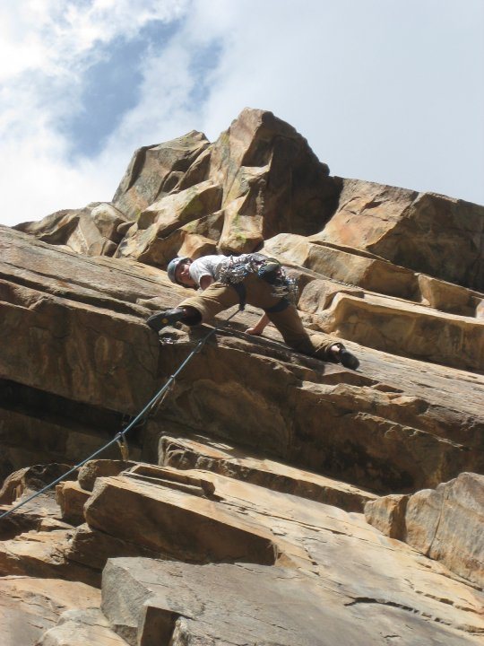
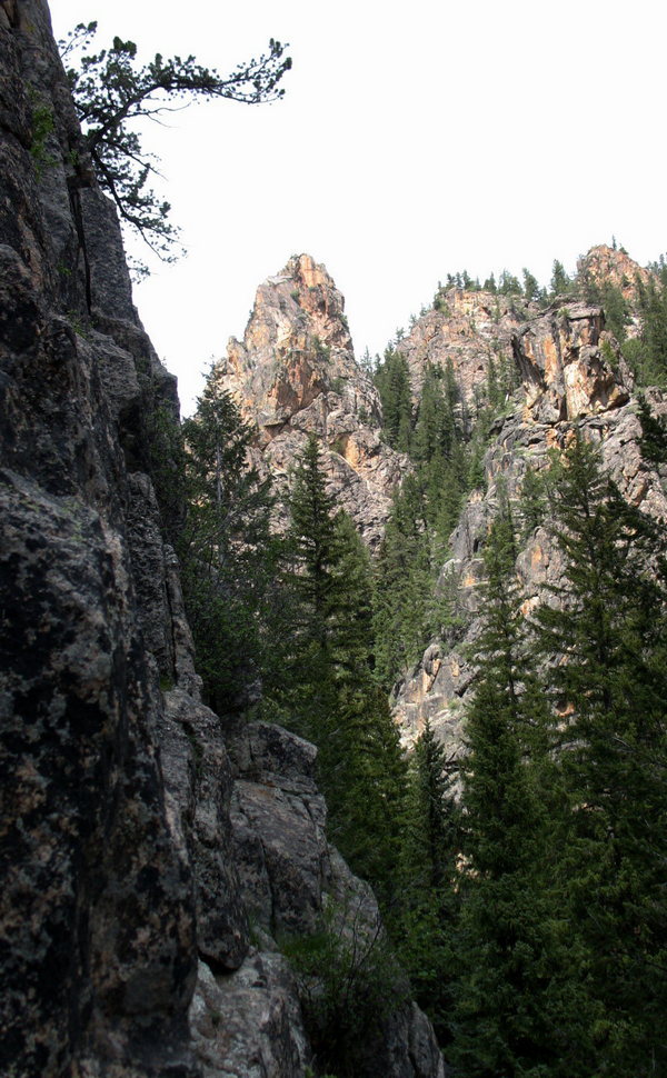
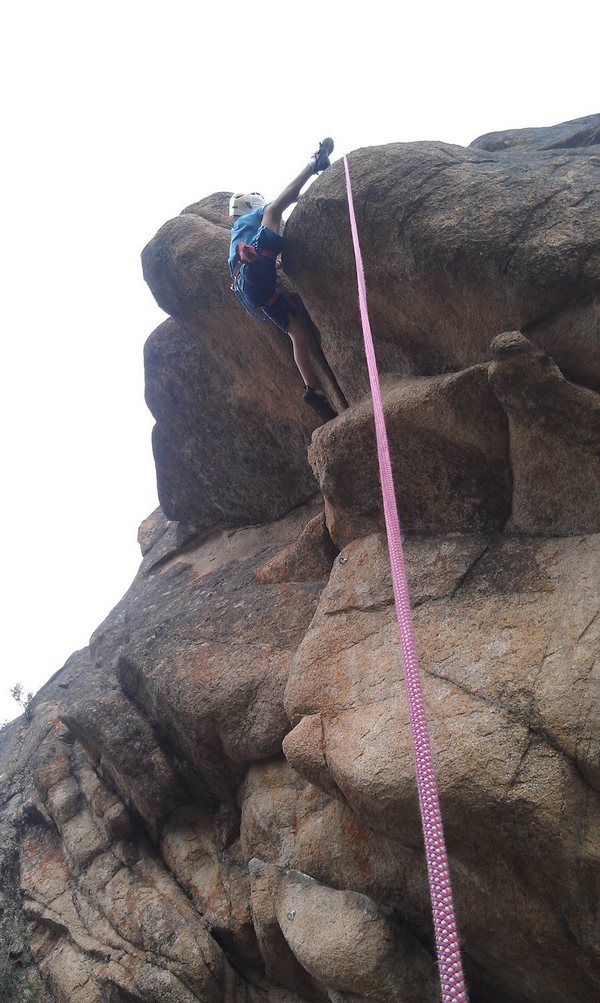
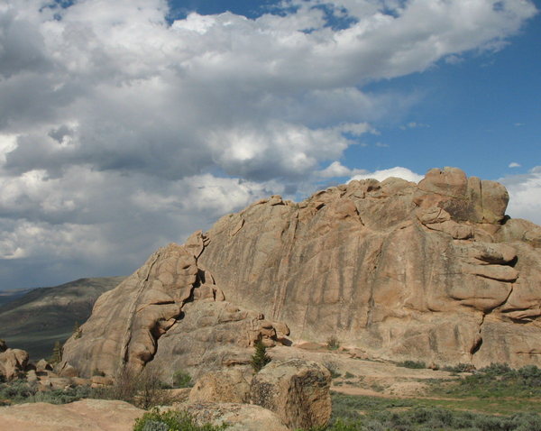
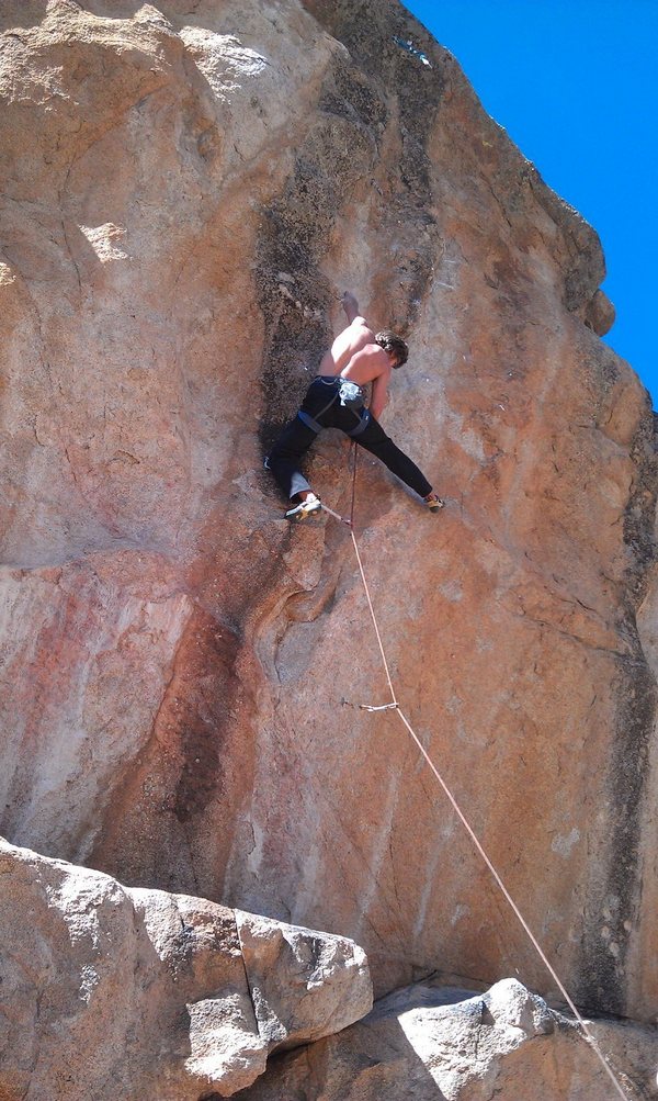
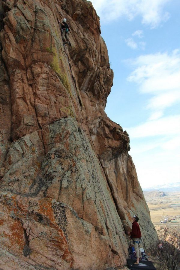
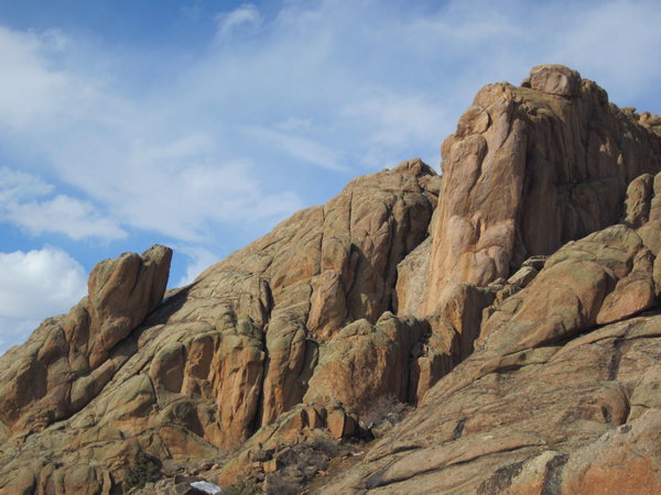
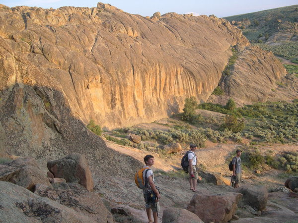
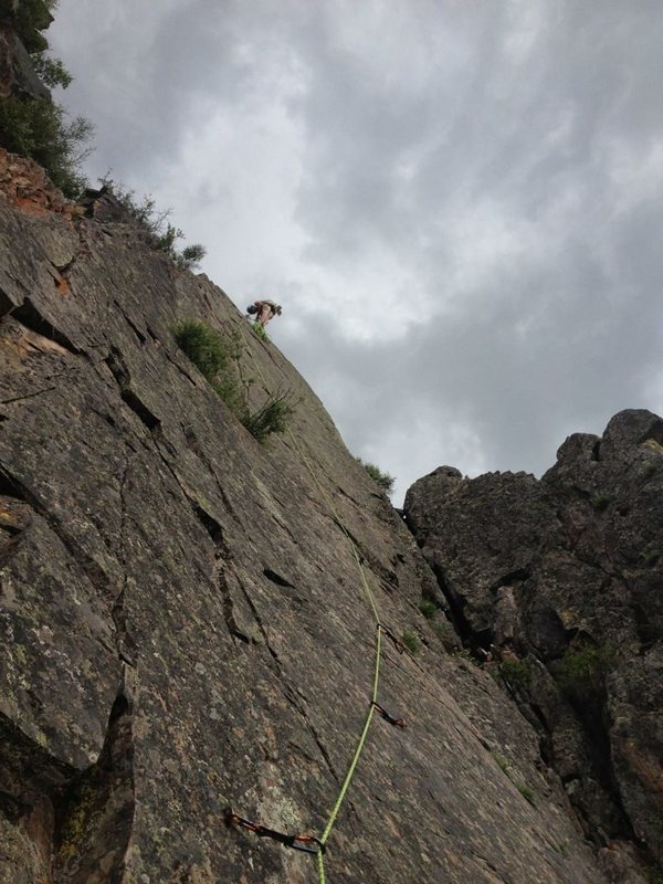
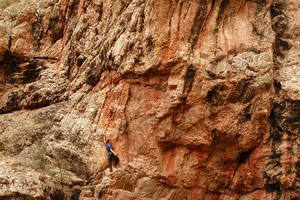
West of Gunnison is the Black Canyon of the Gunnison National Park, deep and narrow with with routes as long as 2,000 feet. Hartman Rocks is a multi-use area administered by the BLM, the City of Gunnison, and Gunnison County. Bike, hike, camp, bouldering, and traditional climbing are all part of the Hartman Rocks experience. Taylor Canyon has options which include rock climbing, camping, paddling, fishing, mountain biking, and hiking. If the Harmel’s Area of Taylor Canyon is crowded, a short drive to Spring Creek (which drains into the Taylor River), has fewer folks along with nice walls, towers, and crags to explore. Thinking of a degree in Recreation and Outdoor Recreation, Western State Colorado University in Gunnison is a large draw for students invested in outdoor activity. Looking for a wide variety of climbing options, Gunnison is worth the investigation for a Colorado Climb.
[wpgmza id=”102″]
Alpine Tunnel, Palisades Rock Climbing: 0 Routes
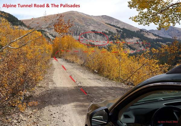 Located above the town of Pitkin, in eastern Gunnison County, provides climbing opportunities along the Palisades. The Palisades are granite cliffs next to the rail road grade (today’s Forest Service road) just below the western portal of the tunnel. Access is easy, just above Pitkin, on the road to Tincup, take FS Road 839.
Mountainproject.com: Alpine Tunnel, Palisades Rock Climbing
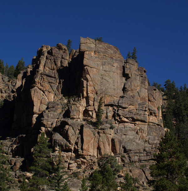
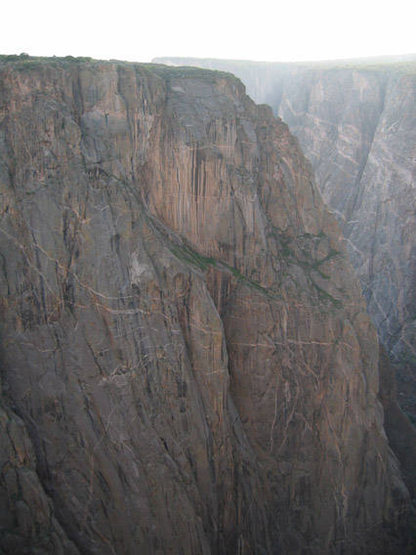
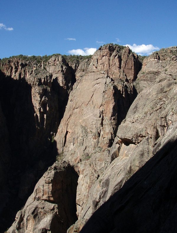
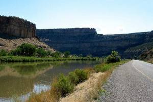
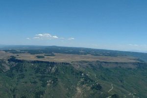
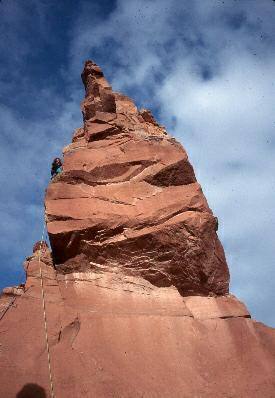
Black Canyon of the Gunnison: 126 Routes
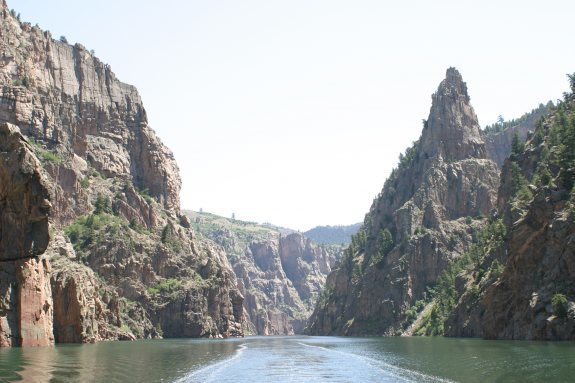 The Black Canyon of the Gunnison is located just west of Gunnison (east of Montrose) off of Highway 50. There are two rims, the South Rim just north of Highway 50, and the North Rim located just south of Highway 92.
Westerncooutdoors.com: Black Canyon Rock Climbing
Mountainproject.com: Black Canyon Rock Climbing
Blue Mesa Inlet Rock Climbing: 3 Routes
 Located east of Gunnison, off of Highway 50 before reaching the the Lake City Turnoff, Highway 149.
Mountainproject.com: Blue Mesa Inlet Rock Climbing
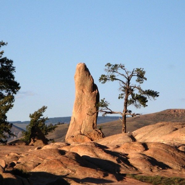
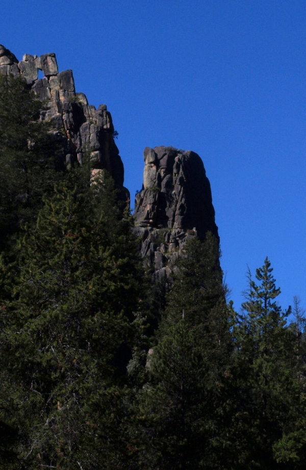
The Castles Rock Climbing: 0 Routes
 The Castles are high towers located in the West Elk Wilderness Area, north west of Gunnison. Access is from Forrest Service Road 730. Take Highway 135 north of Gunnison for several miles until reaching the turnoff for the Ohio Valley (FS 730).
Mountainproject.com: The Castles Rock Climbing
Cement Creek Rock Climbing: 16 Routes
 Located north of Gunnison (south of Crested Butte) off of Highway 135
Mountainproject.com: Cement Creek Rock Climbing
Gate View Canyon Rock Climbing: 18 Routes
 Traveling on Highway 50 west of Gunnison to the turnoff to Lake City (Highway 149), continue on until reaching the Blue Mesa Cutoff which will be on the right side of the road. Taking the “Cutoff” until reaching signage for Gate View.
Mountainproject.com: Gate View Rock Climbing
God’s Crag Rock Climbing: 26 Routes
 At the town of Lake City, take the road to Engineer Pass (Henson Creek Road). Taking the Henson Creek Raod for 7.2 miles, God’s Crag will be located on the right side of the road. Watch for ticks when in the climbing area.
Mountainproject.com: God’s Crag Rock Climbing
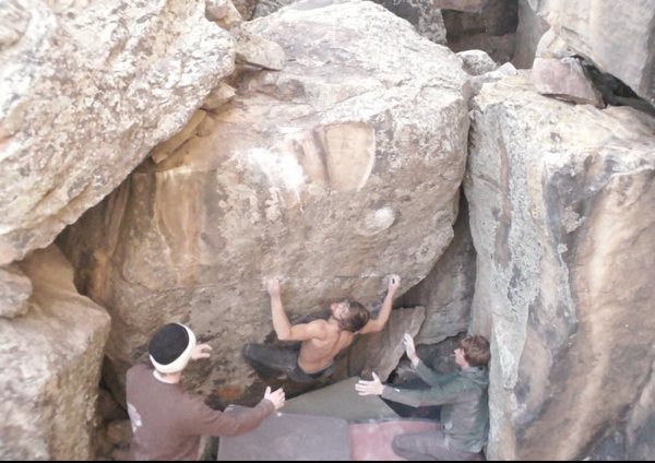
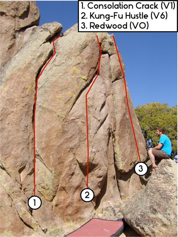
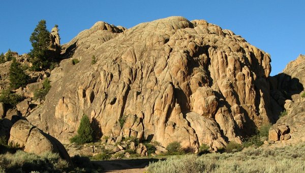
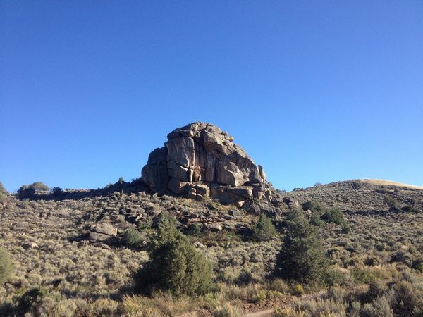
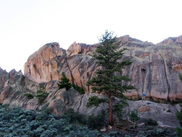
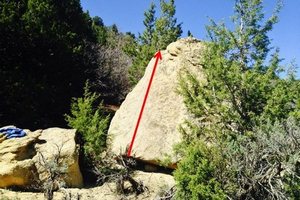
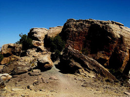
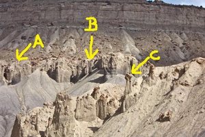
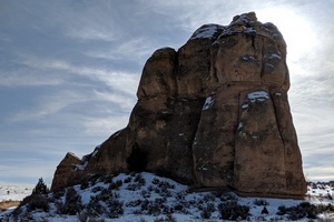
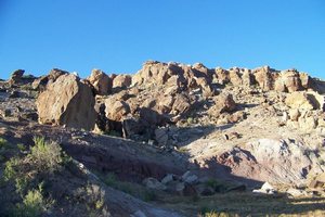
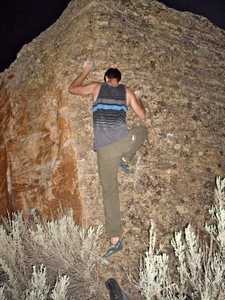
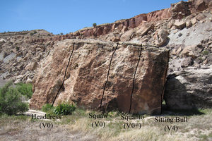
Hartman Rocks Rock Climbing: 177 Routes
 From the town of Gunnison, drive on Highway 50 west, just past the Gunnison Air Port will be a sign for Hartman Rocks. Turn left and continue past the KOA campground.
Westerncooutdoors.com: Hartman Rocks Rock Climbing
Mountainproject.com: Hartman Rocks Rock Climbing
Lamphier Lake Area Rock Climbing: 1 Route
 From Gunnison drive on Highway 50 east to Parlin. Take FS 76 to Ohio City. The climbing area is located just north of Ohio City and the Gold Creek Campground.
Mountainproject.com: Lamphier Lake Area Rock Climbing
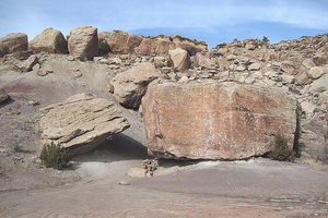
Lost Canyon Bouldering: 12 Routes
 From the town of Gunnison drive north on Highway 135 toward Crested Butte. At 7.2 miles from the last stop light, there will be a set of mail boxes and a candy striped pole on the right side of the road. The cliff band can be seen on the western side of the road.
Mountainproject.com: Lost Canyon Bouldering
The Point, Powderhorn (aka Indian Creek) Rock Climbing: 15 Routes
 From Gunnison travel west on Highway 50, to Highway 149 (Lake City turnoff), just south of Powderhorn, just past MM 97, turn east on CR 58, driving 2.5 miles. There will be a pull off on the left side of the road just before the third cattle guard. From the pulloff there is a 4×4 road about 200 feet down the road, take the 4×4 road on the right (west), follow 200-300 yards to a pullout, past this point follow the trail another 200 feet to the southwest to the climbing area.
Mountainproject.com: The Point, Powderhorn (aka Indian Creek) Rock Climbing
Real Lost Canyon Bouldering: 17 Routes
 From Gunnison take Highway 135 north, get on the right side frontage road, from the frontage road drive right on CR 10 (Lost Canyon Road), follow CR 10 (dirt road) past houses, when reaching the firing range on the left, continue on for the pulloff several hundred yards on the right. The bouldering area will be on the other side of the road.
Mountainproject.com: Real Lost Canyon Bouldering
Sac Snag Tower Rock Climbing: 1 Route
 Located just west of the Blue Mesa Dam above Highway 92.
Mountainproject.com: Sac Snag Tower Rock Climbing (Hwy 92 Cliff Band Rock Climbing)
Spring Creek: 26 Routes
 Travel north of Gunnison to Almont; at Almont travel on Road 742 (up the Taylor River) to the Harmel’s Resort. At Harmel’s turn on to Road 744 (Spring Creek). From the end of the pavement (2 miles), watch for climbing areas.
Mountainproject.com: Spring Creek Rock Climbing
Willow Creek Bouldering: 10 Routes
Travel east from Gunnison on Highway 50, at Parlin take the turnoff to Ohio City (Road 76). There is a gate on the left side of the road as you reach Ohio City (the first section of this road is private, please respect the property owner, follow this road until seeing the public lands sign. Once on public lands, the boulder area will be obvious. ]]>
- Rock Climbing (177 Routes)
- Mountain Biking (45 miles single track, 45 miles double track)
- Hiking
- Camping (permitted at established fire rings)
- Horseback Riding
- Off-highway Vehicles (45 miles of trails, 45 miles of road)
- Cross Country Skiing (16 miles of groomed trail)
Access from Highway 50: turn south on West Airport Road (County Road 38) for 2.5 miles to the Parking Area.
Because of the close proximity of the climbing areas to one another, check the map for locations.
[wpgmza id=”103″]
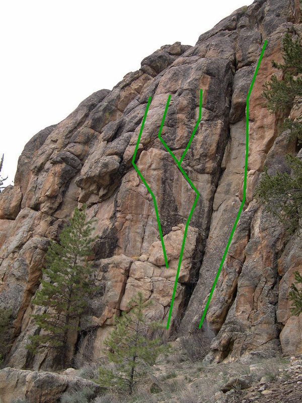
Bambi’s Trail Area Bouldering: 11 routes
 Camels Head Boulder: 1 route
Crash Site: 1 route
The Hueco Boulder: 1 route
The Island: 7 routes
Unknown Boulder
Mountainproject.com: Bambi’s Trail Area Bouldering
Bambi’s Trail Rock Climbing: 1 route
 Bambi’s Belly: S 5.11-
Mountainproject.com: Bambi’s Trail Rock Climbing
Beginners Slab Rock Climbing: 7 Routes
 Devil’s Spine, aka Bajorn: S, TR 5.7
Ferringy: S, TR 5.7
Unknown 1: TR 5.6
Cardassian: S, TR 5.9
Baby’s Got Crack: T 5.10d
Crack, Baby!; T 5.7
Turtle Back Crack: T 5.7
Mountainproject.com: Beginners Slab Rock Climbing
Best Crack Wall: 5 routes
 Best Crack: T 5.10a
Electric Lightning: T 5.7
Joe Cocker’s Toe Jam: S 5.11
Open Project: T Easy 5th
Straight to Hell: T 5.11a R
Mountainproject.com: Best Crack Wall Rock Climbing
Bouldering Areas:
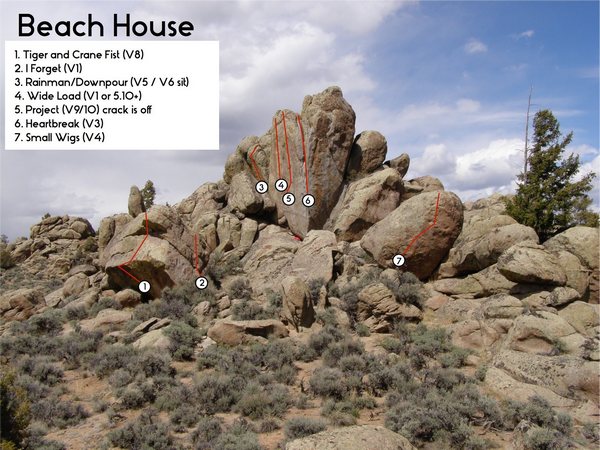 The Beach: 15 routes
The Candy Man Boulder: 3 routes
Deffy’s Artes: 0 routes
The Far Side: 13 routes
The Other Side: 15 routes
Pre-Teen Area: 2 routes
Quarter Inch Master Area: 5 routes
The Roof Crack: 2 routes
Son of Sam Area: 0 routes
The Stash: 18 routes
Suppermodel Area: 1 route
White Lightning Area: 4 routes
Mountainproject.com: Bouldering Areas Bouldering
Buddha’s Belly Wall Rock Climbing: 6 Routes
 Unnamed 5.8: T 5.8
Ramayana Story: S, TR 5.11a
Unnamed 5.6: T,TR 5.6 PG13
Laughing Buddha: S 5.11a
Buddha’s Belly: S, TR 5.10b
Doba’s Drama: S 5.11c/d
Mountainproject.com: Buddha’s Belly Wall Rock Climbing
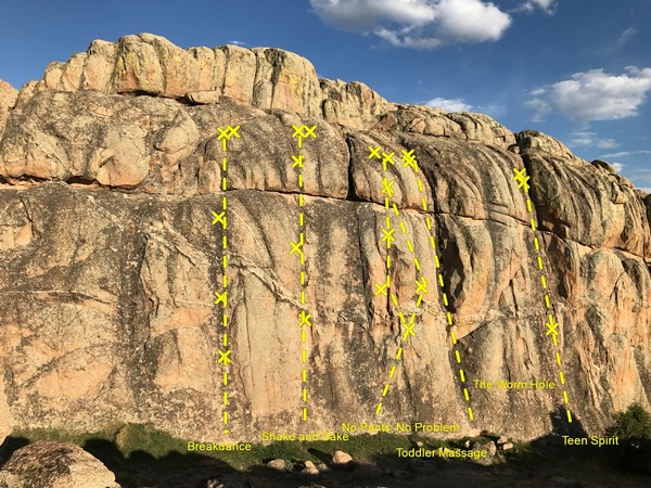
The Corridor: 6 Routes
Breakdance: S 5.10Shake and Bake: S 5.10
No Pants, No Problem: S 5.11
Toddler Massage: T 5.10
The Worm Hole: T, TR 5.7
Teen Spirit: T 5.7 X
Mountainproject.com: The Corridor Rock Climbing
Cut the Rope Wall, aka Tom Sawyer Wall: 4 routes
 Huckelberry’s Fin: TR 5.12+
All Things Ninja: S 5.9+
Runaway Jim: S 5.9+
Every Day is a Gift: S 5.8
Mountainproject.com: Cut the Rope Wall, aka Tom Sawyer Wall
Groove Rock, aka Leap of Faith Area: 3 routes
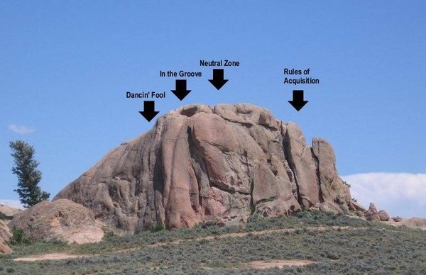 Dancin Fool: T 5.9
Neutral Zone: T 5.9
Rules of Acquisition: S 5.10a/b
Mountainproject.com: Groove Rock, aka Leap of Faith Area
Kill Hill Boulder Area: 12 routes:
 Duck Boulder: 1 route
Fish Head Boulder: 2 routes
Grey Lightning: 2 routes
Heroin Tracks Boulder: 0 route
Nickles Boulder: 1 route
Ninja Boulder: 1 route
Water Groove Area (top of Kill Hill): 4 routes
Y Crack Boulder: 1 route
Mountainproject: Kill Hill Bouldering Area
Little Finger, aka Penis Rock Climbing: 4 Routes
 Little Finger aka Penis Rock South Face: S 5.10c
Pinnacle Gully- Chungas Revenge: S 5.7
Pinnacle Gully- Pajama People: T 5.8
Pinnacle Gully- Wowie Zowie: S 5.8
Mountainproject.com: Little Finger, aka Penis Rock Climbing
Predators’ Perch Rock Climbing: 2 Routes
 Unknown: T, TR 5.10
Warpity: T, TR 5.10
Mountainproject.com: Predators’ Perch Rock Climbing
Project Wall: 1 route
 Cobra Strike: S 5.14b
Mountainproject.com: Project Wall Rock Climbing
Resistance Wall: 3 routes
 Mystery Flake: T 5.9
Resistance is Futile: S 5.8
Sick Day: S,T 5.8-
Mountainproject.com: Resistance Wall Rock Climbing
Rock ‘N Roll Wall Rock Climbing: 4 Routes
 Open Project: S easy 5th
The Gift of Sport aka Between a Pimp and a Hard Place: S 5.12
The Gift of Trad: T, S 5.12
Watching in Silance: S 5.9
Mountainproject.com: Rock ‘N Roll Wall Rock Climbing
Slab of No Return: 3 routes
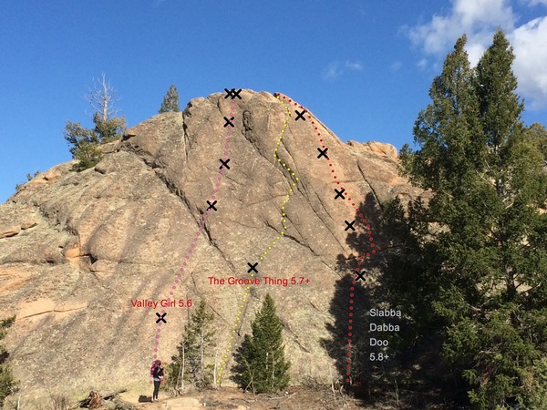 Valley Girl: S 5.6
The Groove Thing: T,TR 5.7+
Slabba Dabba Doo: S 5.8+ PG13
Mountainproject.com: Slab of No Return Rock Climbing
The Slot: 6 Routes
 Mustang Sally: S 5.10b
Snoop Doggy Dog: S 5.10b
Voodoo Butter: S 5.9+
Muffin Man: S 5.10a
Walk the Dog: S 5.7
Motza Balls: S 5.10c
Mountainproject.com: The Slot Rock Climbing
Super Slabs: 6 routes
 The Pink Nipple: T 5.10d
Shape Shifter: T 5.10a
Unknown route betweek Shape Shifter and Joker: S 5.8+
The Joker: T 5.9+
The Riddler: T 5.9
Keating Beating: T 5.10a
(In honor of the famous phrase at Western, “I just took a beating at Keating” dining hall?)
Mountainproject.com: Super Slabs
Teenage Wasteland: 6 routes
 Route 2, ska Primal Instinct: T 5.10a
Back in Black: T 5.9
Cross Town Traffic Right: S 5.8+
Route 5: T 5.9
Magic Bus: T 5.9 PG13
Easy Slab: T 5.55
Mountainproject.com: Teanage Wasteland
Tiger Wall: 9 routes
 Pussy Foot: S 5.9
Feline Grace: S 5.11-
Kitty Cat Kicked My Ass: S 5.12a
Tiger Shark: S 5.12c
Statement in You: S 5.12a
Crystal Ship: S 5.12a
Eye of the Tiger: S 5.11+
Tigers and Goats: S 5.11
Cat Daddy Wu-Wu: T, S 5.11
Mountainproject.com: Tiger Wall ]]>
Taylor Canyon Climbing
[wpgmza id=”100″]
Harmel’s Area Climbing
[wpgmza id=”101″]
Coffin Crag: 2 Routes

From the Rosy Lane Campground looking across the Taylor River is the Coffin Crag. A short distance up river from the PCP Pinnacle is a tryolean going across the river. After crossing the river, hike about 1/2 mile to the east to the area of Coffin Crag.
Mountainproject.com: Coffin Crack Crag Mountain Climbing
First Buttress: 41 Routes
 Located just up river from Harmel’s Resort in middle Taylor Canyon.
Mountainproject.com: First Buttress
The Frenchman Buttress: 1 Route
 Located about a mile below the Taylor Park, after passing the Lottis Creek Campground, cross the river and look up to the left to see the buttress. There is a parking pullout just past the private property.
Mountainproject.com: The Frenchman Buttress Rock Climbing
Gunnison Mountain Park Picnic Area: 3 Routes
 Located in the Taylor River Canyon, about 3.2 miles east of Almont, with good signage. The climbing face is just above the parking lot.
Mountainproject.com: Gunnison Mountain Park Picnic Area Rock Climbing
North Bank: 12 Routes
 Located on the road to the North Bank Campground.
Mountainproject.com: North Bank Rock Climbing
PCP Pinnacle: 2 Routes
 Located across from the Rosy Lane Campground. Parking at a pullout on the right side of the road, not in the campground.
Mountain Project.com: PCP Pinnacle Rock Climbing
Rosy Lane: 5 Routes
 Located across the river from the Rosy Lane Campground. There is day use parking within the campground, or pullout parking across the road on the right side.
Mountainproject.com: Rosy Lane Rock Climbing
Second Buttress: 11 Routes
 Located just to the north of the First Buttress in middle Taylor Canyon.
Mountainproject.com: Second Buttress Rock Climbing
Taylor Canyon Bouldering: 68 Routes
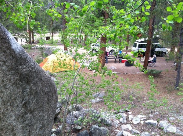 Located above the Rosy Lane Campground in Taylor Canyon. Many of the campgrounds in the canyon have boulders, giving climbers easy access to camp and climb.
Mountainproject.com: Taylor Canyon Bouldering
The Tilt Wall: 6 Routes
 Found by taking the North Bank Trail to the east up Taylor Canyon, up the gulch, with the Tilt Wall being found just past a small talus field, up and on the right side of the gulch.


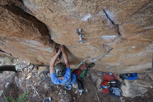
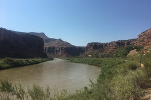
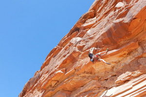
With a length of 48 miles, from the dam Blue Mesa Reservoir downstream to the middle of the Gunnison Gorge National Conservation Area, the Black Canyon provides experienced climbers a tight narrow canyon with some of the tallest vertical wall climbing in Western Colorado. The Painted Wall, at 2,500 feet is the tallest vertical wall in the state of Colorado. The National Park contains only 12 miles of the Gunnison River gorge and contains 145 routes, eight are rated at 5.8; twenty-one are rated at 5.9, the remaining climbing routes have ratings between 5.10 and 5.13.
Black Canyon of the Gunnison NP: Rock Climbing Link
Black Canyon of the Gunnison Backcountry Map Pdf.
Within the National Park, a designated wilderness area, the parks Climbing Management Plan is the foundation for planning a climb. The main climbing season is from the middle of April to the early part of June. The fall season begins in September to early November. Climbers should be aware for the following challenges:
- The National Park has entrance and camping fees.
- To climb and travel in the canyon a wilderness permit (free) is required.
- There is no gathering of wood for fires.
- In the inner canyon there are no campfires.
- Pets are not allowed in the inner canyon, are allowed only in designated areas, and have to be attended to at all times within the Park.
- Littering is not tolerated, visitors are encourage to follow the Leave No Trace
 7 Principals.
It is noteworthy that the park service closes climbing access in the Black Canyon area due to nesting raptors in the spring (seasonal). Crossing the Gunnison River for climbing access can be an issue with careful planning required.
[wpgmza id="99"]
Upriver from the Park is the Curecanti National Recreation Area, consisting of the three reservoirs (Blue Mesa, Morrow Point and Crystal) in the Black Canyon. The Morrow Point reservoir is the location of the Curecanti Needle:
Curecanti Needle: 3 Routes
The Curecanti Needle is located about 5 miles below the Blue Mesa Dam. Access is from Hwy 50, see MountainProject.com: Curecanti Needle.
Black Canyon of the Gunnison National Park Climbing:
Marmot Rocks: 4 Routes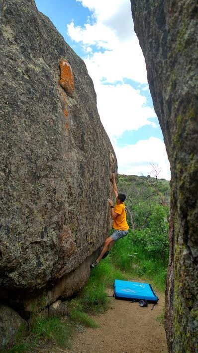 Located in the Park along the South Rim Drive, between the Painted Wall and Cedar Point Overlooks, on the south side of the road. Parking at the Painted Wall Overlook, hiking along the road until it bends to the right, then a trail to the boulders. The boulders are visible on the south side from the road. At the Visitor Center there is a brochure on bouldering at Marmot Rocks.
Mountainproject.comn: Marmot Rocks Bouldering
Located in the Park along the South Rim Drive, between the Painted Wall and Cedar Point Overlooks, on the south side of the road. Parking at the Painted Wall Overlook, hiking along the road until it bends to the right, then a trail to the boulders. The boulders are visible on the south side from the road. At the Visitor Center there is a brochure on bouldering at Marmot Rocks.
Mountainproject.comn: Marmot Rocks Bouldering
South Rim Rock Climbing: 25 Routes
 The South Rim features longer routes with colder temperatures and easier access than the North Rim.
Mountainproject.com: South Rim Routes Rock Climbing
The South Rim features longer routes with colder temperatures and easier access than the North Rim.
Mountainproject.com: South Rim Routes Rock ClimbingNorth Rim Routes: 91 Routes
 North Rim features terrific and terrifying routes of a shorter length with warmer temperatures.
Mountainproject.com: North Rim Routes Rock Climbing
North Rim features terrific and terrifying routes of a shorter length with warmer temperatures.
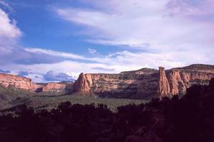
Mountainproject.com: North Rim Routes Rock ClimbingGrand Junction in Mesa County is the largest city on Colorado's Western Slope. Located in the midpoint of the Grand Valley, this service center boasts access to 2,693 climbing routes within a 40 mile radius. Mild winter temperatures support climbing activity in the spring and fall seasons. The chief advantage of the Grand Junction area is the massive number and variety of climbs that lie within a close proximity, giving climbers endless options for activity.
ARC'TERYX Presents Weekends with Piz - Weekend Warriors from ARC'TERYX on Vimeo.
[wpgmza id="97"]
Bangs Canyon: 13 Routes
 Located just before the East Entrance of Colorado National Monument: Broadway to Rim Rock Drive, 1 block to left on D Road, becoming Rosevale and Little Park Roads, 5 miles to the crest of the hill, turnoff to Rough and Bangs Canyons at the first left.
MountainProject.com: Bangs Canyon
Bookcliffs: 3 Routes
 Mountains located just to the north of the City of Grand Junction.
MountainProject.com: Bookcliffs
Bullet Hole Boulder Area: 38 Routes
 Located just off of Monument Road, .25 miles past the Tabeguache Trail Head, parking is on the right.
MountainProject.com: Bullet Hole Boulder Area
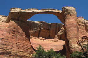
Colorado National Monument: 181 Routes
 Colorado National Monument is located just south of the City of Grand Junction.
MountainProject.com: Colorado National Monument
Colorado NM Climbing Page Link
De Beque Canyon: 38 Routes
 The Colorado River flows through De Beque Canyon in eastern Mesa County, I 70 access.
MountainProject.com: De Beque Canyon
Dominguez Canyon: 2 Routes
 Located south-east of Grand Junction, includes the Dominguez-Escalante National Conservation Area (210,172 acres). The Dominguez Canyon Wilderness Area (66,280 acres included in the NCA) is managed by the BLM, and is their largest roadless area in Colorado. The Wilderness Area sits in the middle of the NCA, showcases Big and Little Dominguez Canyons. This area consists of red rock canyons with sandstone bluffs, all part of the Uncompahgre Plateau.
MountainProject.com: Dominguez Canyon
Dominguez-Escalante NCA Map Pdf
Dynamite Shacks: 65 Routes
 Located just across from the Tabeguache Trail Head on Monument Road, parking on the right.
MountainProject.com: Dynamite Shacks
Escalante Canyon: 81 Routes
 Escalante Canyon lies in the south eastern part of the Dominguez-Escalante National Conservation Area. Not included in the Dominguez Canyon WA, this section of the NCA allows for vehicle access on established roads.
MountainProject.com: Escalante Canyon
Dominguez-Escalante NCA Map Pdf
Grand Mesa (Lands End): 82 Routes
 Take Highway 50 east of Grand Junction, 13 miles, travel east on Kannah Creek Road, follow signs to Lands End.
MountainProject.com: Grand Mesa (Lands End)
Holy Cross Boulders: 18 Routes
 From Grand Junction, Broadway to Rim Rock Drive, 1 block to left on D Road, becoming Rosevale and Little Park Roads, parking is at the Lunch Loop TH, just past the last house located on the right side of Little Park Road.
MountainProject.com: Holy Cross Boulders
McInnis Canyon Bouldering: 4 Routes
 Trail Head is just off of Hwy 340 (I70, Fruita exit), take Kings View Road (west) to Devil's Canyon Road, parking on the right.
MountainProject.com: McInnis Canyon Bouldering
McInnis Canyons: 8 Routes
 The McInnis Canyons National Conservation Area is located just north-west from the Colorado National Monument, and consists of 123,430 acres of BLM administered land. This NCA contains the Black Ridge Canyons Wilderness Area, which has 75,000 acres and the largest concentration of natural arches in North America
MountainProject.com: McInnis Canyons
Palisade: 19 Routes
 Climbing on Mt. Garfield area, access is by the Mt. Garfield Trail Head just north of the town of Palisade. The attraction is climbing the towers of talus located along the interstate.
MountainProject.com: Palisade Climbing
Rabbit Valley: 2 Routes
 Located west of Grand Junction, Rabbit Valley sits on the Colorado-Utah state line. The Rabbit Valley Staging Area is south of the interstate, use Exit 1.
MountainProject.com: Rabbit Valley
Rattlesnake Canyon: 1 Route
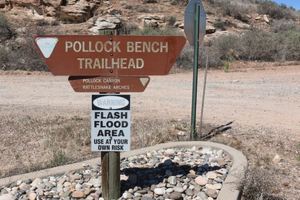 Rattle Snake Canyon is part of the McInnis NCA, located north-west of the Colorado National Monument. Rattle Snake Canyon is located in the Black Ridge Canyons Wilderness Area. Hiking in from the Pollock Bench TH makes a round trip length of 15.5 miles. A second trail head south of the canyon is the shortest route to the Canyon, however it requires a high clearance four wheel drive vehicle for the last several miles. See McInnis Canyons above.
MountainProject.com: Rattlesnake Canyon
Riggs' Hill: 73 Routes
 Named for Elmer S. Riggs, a paleontologist with the Field Museum of Natural History, the hill area is thought of as the first dinosaur quarry in Western Colorado. This area is littered with large boulders, for bouldering.
Mountainproject.com: Riggs' Hill
Rough Canyon: 13 Routes
 Located east of the Colorado National Monument, off of Little Park Road; at the Tabeguache Trailhead.
Mountainproject.com: Rough Canyon
South Camp: 17 Routes
 South Camp Bouldering Area is located off of South Broadway on South Camp Road on the Redlands. The desert hills in this area also the location for the Bullet Hole Boulders and the Dynamite Shacks area.
Mountainoroject.com: South Camp Bouldering
The Swimming Hole: 4 Routes
 Trail Head parking is at the Rustlers Loop TH, near Loma. Hike along the trail towards the Colorado River. The anchors for rappelling are located at the top of the cliff over the River.
Mountainproject.com: the Swimming Hole Rock Climbing
Tabeguache Boulders: 12 Routes
 This boulder area is near the eastern boundary of the Colorado National Monument. Cross the Colorado River on Broadway, to Monument Road, follow south for 1.7 miles until reaching the Tabeguache/Lunch Loop TH (the same parking area for Dynamite Shacks), boulder area is located off the Tabeguache Trail.
Mountainproject.com: Tabeguache Boulders
Unaweep Canyon: 2019 Routes
 Unaweep Canyon is located just east of Grand Junction, take Highway 50, turning south on Highway 141 south.
[wpgmza id=”96″]
Main Routes:
Ahab Tower: 1
Devil’s Kitchen: 7
Fruita Canyon: 12
Gold Star Canyon: 7
Grand View Spire: 2
The Gypsies: 7
Independence Monument: 7
Irishman’s Temple: 3
Kissing Couple Area: 4
Liberty Cap: 18
Metamorphic Canyon: 10
Monument Canyon: 26
No Throughfare Canyon: 14
Organ Pipe and Pipe Organ Spire: 7
Other Areas: 4
Red Canyon: 6
Sentinel Spire: 4
Terra Tower Buttress: 9
Tiara Rado: 21
Ute Canyon: 12 ]]>
Located in Mesa County, Unaweep Canyon is unique in that it has two creeks that exit the canyon, one flowing south and one north. Highway 141 is the main access route following the canyon between Whitewater and Gateway. The canyon is the only one in the world with a divide in the middle and streams exiting from both ends. The Nine Mile Hill Area, with it's 18% grade, was the original wagon road from the uranium mines in the West End to the mills in Grand Junction.
Unaweep Canyon, with over 1,000 routes, gives climbers both sandstone and granite, with a range from 5.6 to 5.13. Prime climbing is from Spring into the fall each year. The Nine Mile Hill Boulder Area offers hundreds of options ranging from V) to V12. Once reaching the main canyon, climbers find themselves into a zone that is solid metamorphic rock, with cliffs from 150 feet to over 900 feet in height.
9 Mile Hill Boulder Area:
1674 Routes
[wpgmza id="92"]
Main Canyon:
299 Routes, 148 Sport Routes
The Access Fund owns Sunday Wall, Fortress Wall, and Hidden Valley Wall. The central part of Unaweep canyon is made up of metamorphic rock, granite and quartz monzonite walls. This metamorphic rock is some of the oldest in the state, between 1.4 and 1.7 billion years old. The granite in Unaweep is thought to be the same base rock that is found in the Black Canyon of the Gunnison. Many of the clifs on the south side of Hwy 141 are on BLM property, the land on the valley floor is mostly private which provides access challenges for climbers.
Unaweep Granite:
273 Routes, 110 Sport Routes
Access Fund Trail Head:
109 Routes
[wpgmza id="93"]
Mighty Mouse Wall:
38 Routes, located on the south side of Hwy 141, 1.8 miles past Divide Road.
Mothers Buttress:
85 Routes, located 3.1 miles past Divide Road, with lower, middle, and upper crags. This property is owned by Western Colorado Climbers Coalition
Gateway Vacinity, aka The West End:
32 Routes
Traveling along Hwy 141 through Unaweep Canyon, past the granite cliffs of the main canyon, the highway opens up into a large valley with sandstone cliffs in all directions.
[wpgmza id="94"]
Lake City Ice Climbers, Inc. Link
![]()
Lake City Ice Park: The Mountain Project
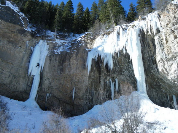
Admission to the Ouray Ice Park is free, climbers are encouraged to join the Ice Park to provide support for this excellent facility.
Hours: Monday- Friday: 8 am- 4 pm
Saturday- Sunday: 7:30 am- 4 pm.
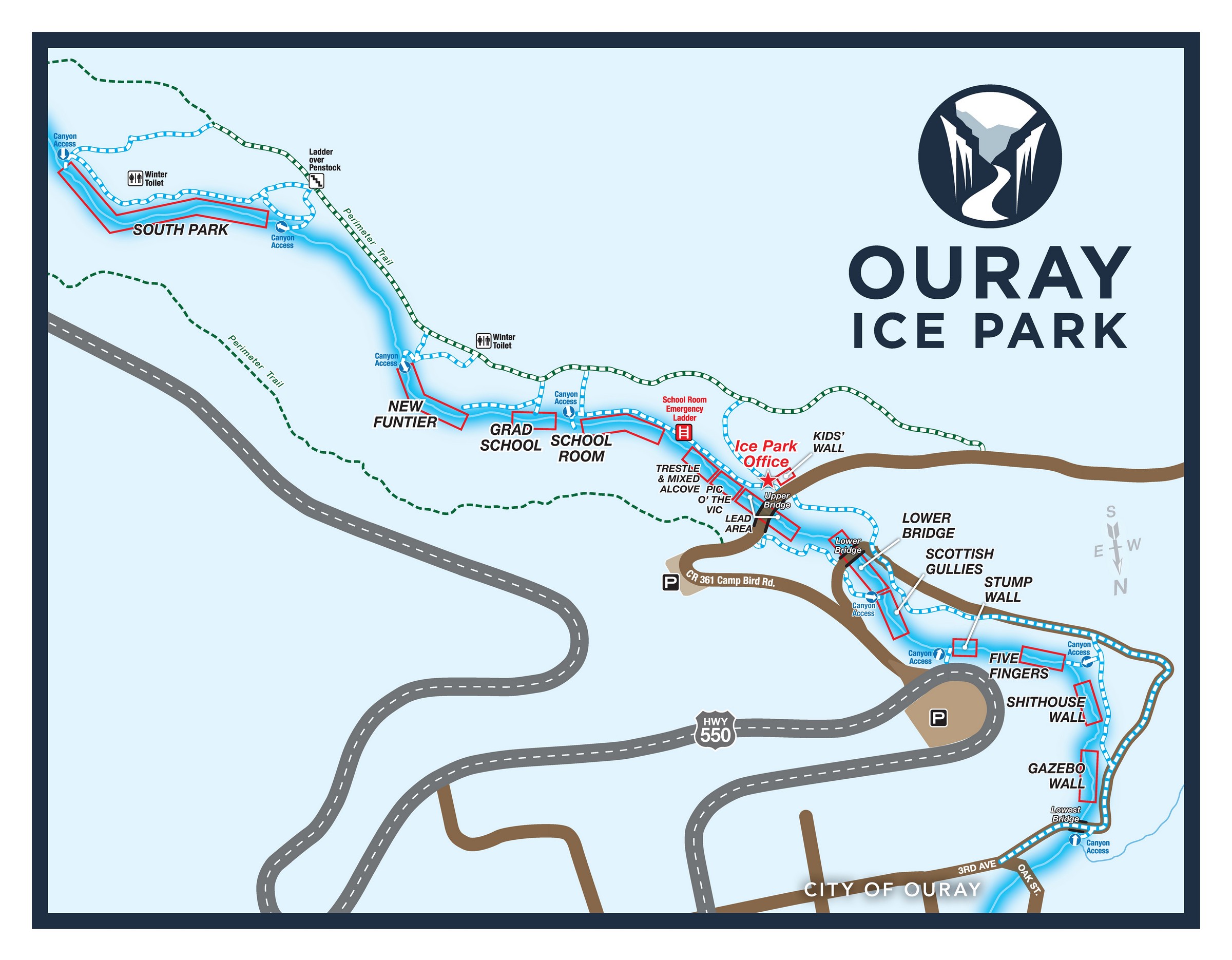
Ouray Ice Park Maps:
Ouray Ice Park Maps:
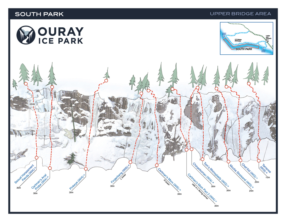
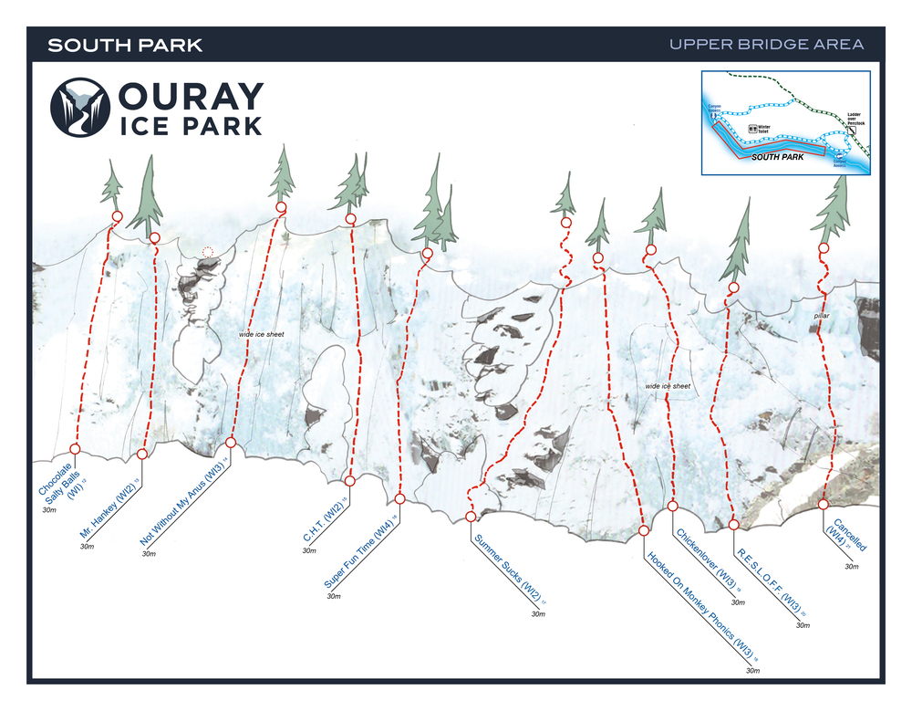
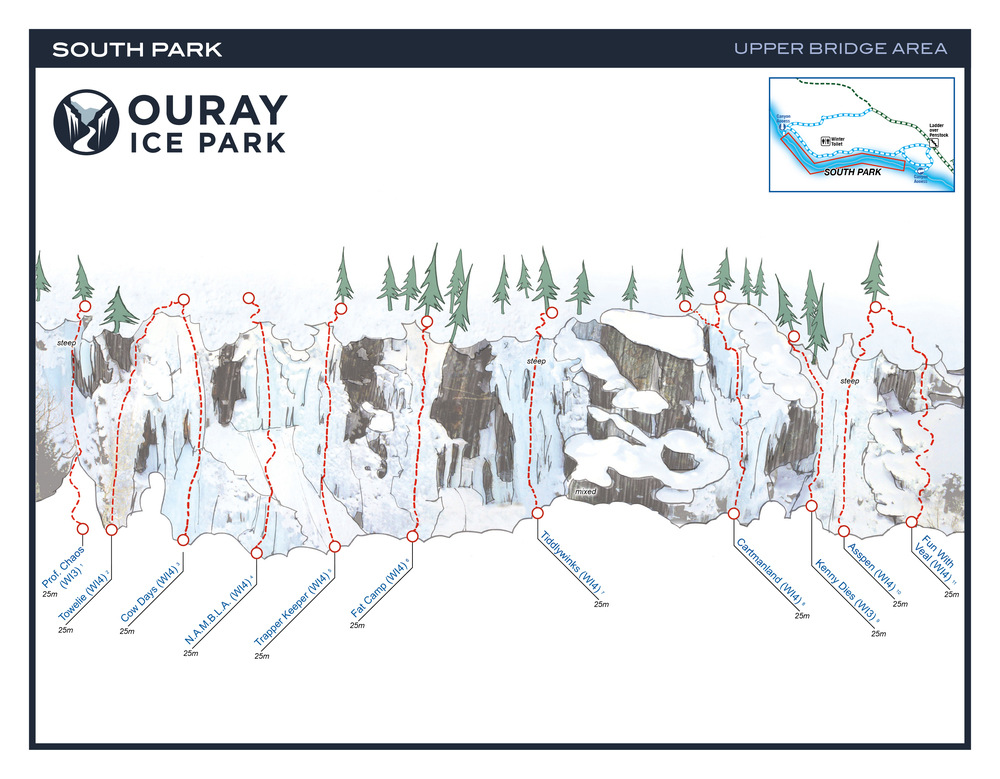
South Park: Upper Bridge Area: WI2- WI5, 32 Routes
Grade Range: WI2- WI5
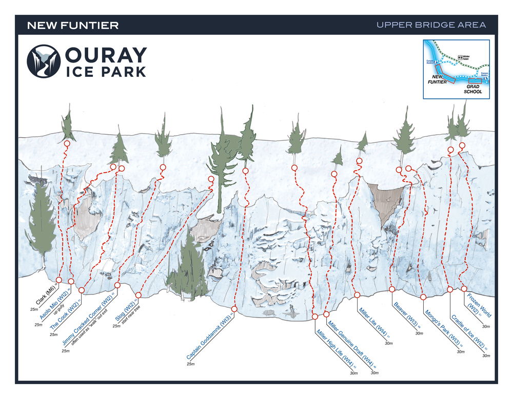
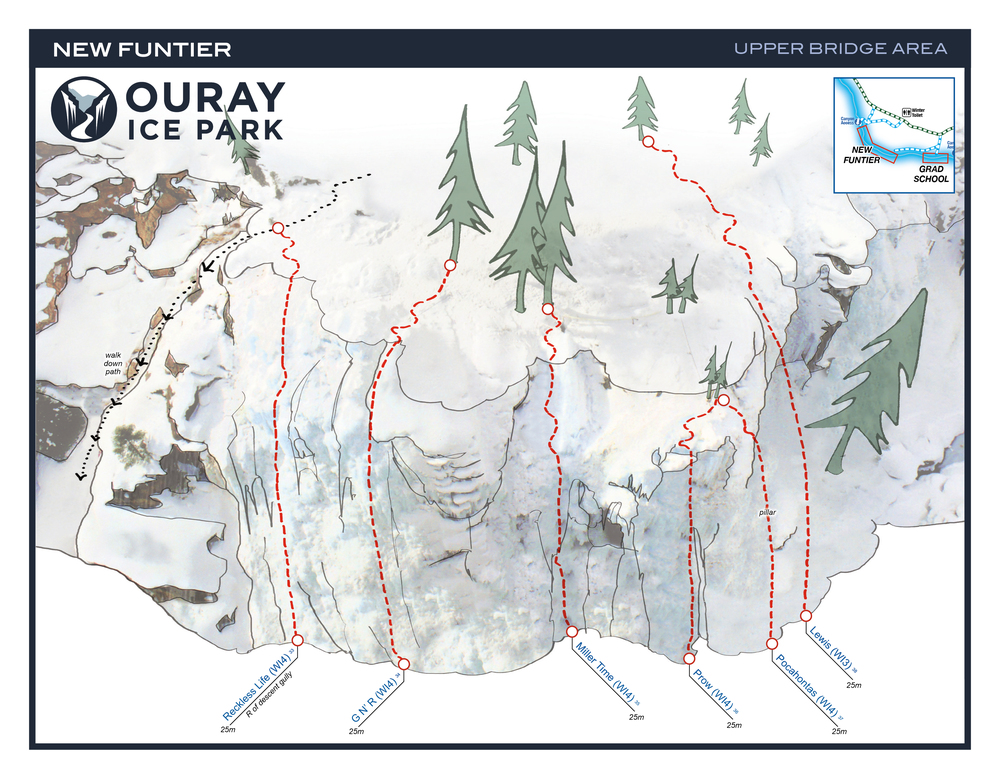
New Funtier: WI2 – WI4, 13 Routes
Grade Range: WI2 – WI4
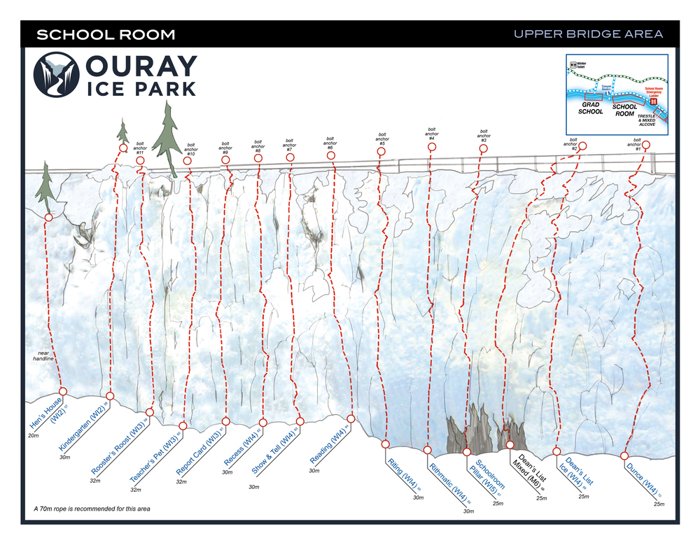
Schoolroom: WI2- WI5, 17 Routes
Grade Range: WI2-WI5 & M4- M6
Trestle + Mixed Alcove: WI3/4- M9, 23 Routes
Grade Range: WI3/4 to M9 Mixed
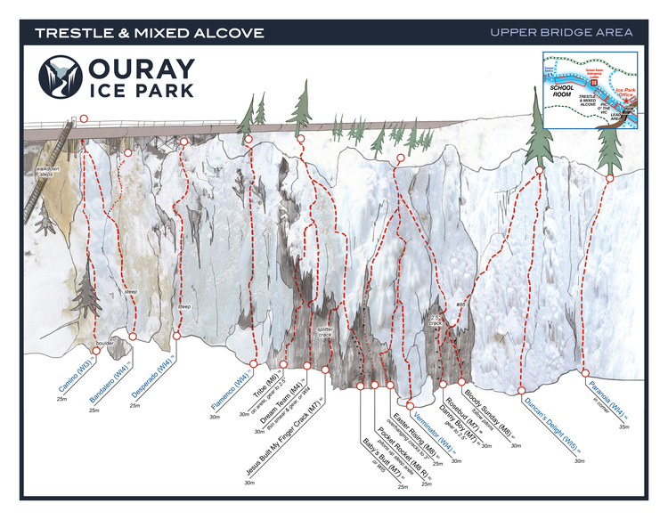
Climbs: “Jesus Built My Finger Crack” (M4, gear)
“Easter Rising” (M8+, gear)
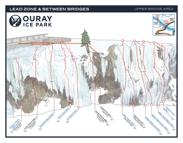
Lead Area – Upper Bridge: WI4/5 to M-hard, 15 Routes
Grade Range: WI4/5 to M-hard “Lead area only, no top roping”
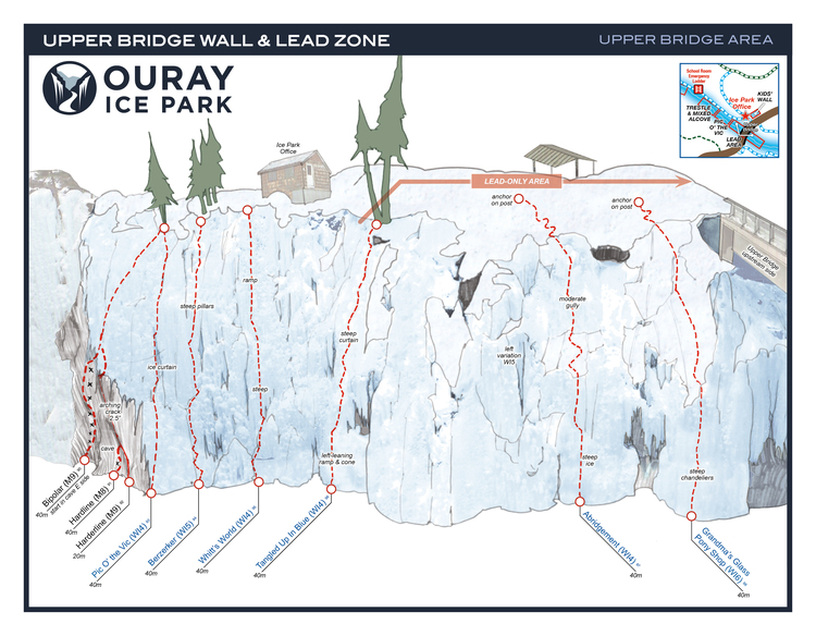
Mixed Routes: Comp Routes Hardline (M9, gear) Fight Ckyb (M7, bolts)
Lower Bridge: WI3 to M9, 31 Routes
Grade Range: WI3 to M9 Mixed
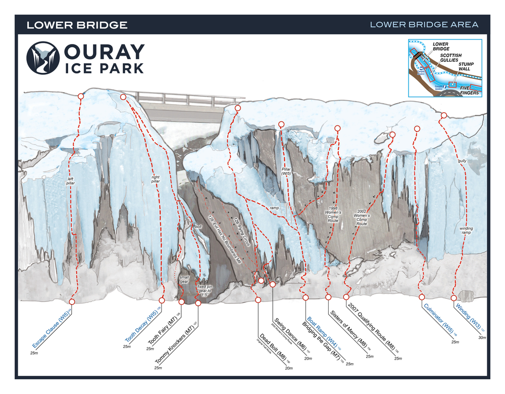
Routes:
Sisters of Mercy (M7, bolts)
Super Dave: (M7), gear
Tic Tac (M7, bolts)
Scottish Gullies, WI2/3- WI4, 6 Routes
Grade Range: WI2/3 – WI4
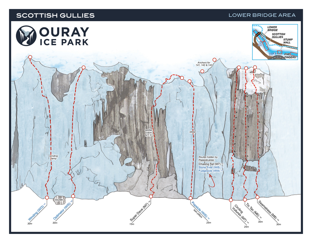
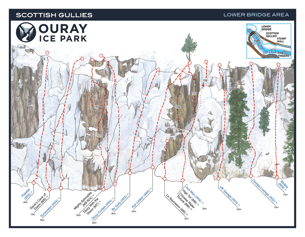
Mixed Routes:
Mighty Aphrodite (M9 R/X, Small Cams and Stoppers)
Dizzy with a Vision (M7, Botls and Ice Screws)
Water Torture (M8, Bolts)
Supremacy Crack (M7/M8, Gear)
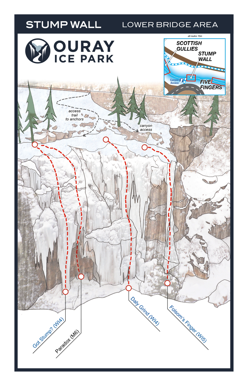
Stump Wall: WI4 – WI5 to M6, 4 Routes
Grade Range: WI4 – WI5 to M6
Five Fingers: WI4 to M7, 10 Routes” open=”false”] Grade Range: WI4 to M7
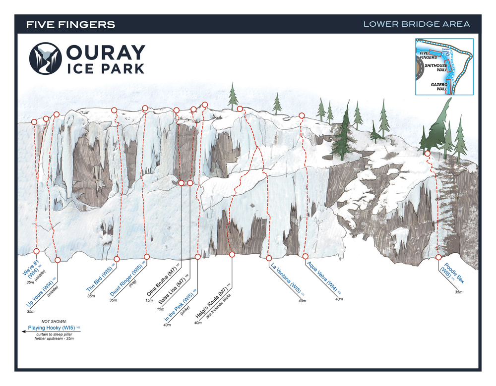
Mixed Climbs: Uddah Bruddah (M7, bolts) Salsa Lisa (M7-, bolts) Helgi’s Route (M7, bolts and gear)
Shithouse Wall: W13 – W15, 5 Routes
Grade Range: W13 – W15

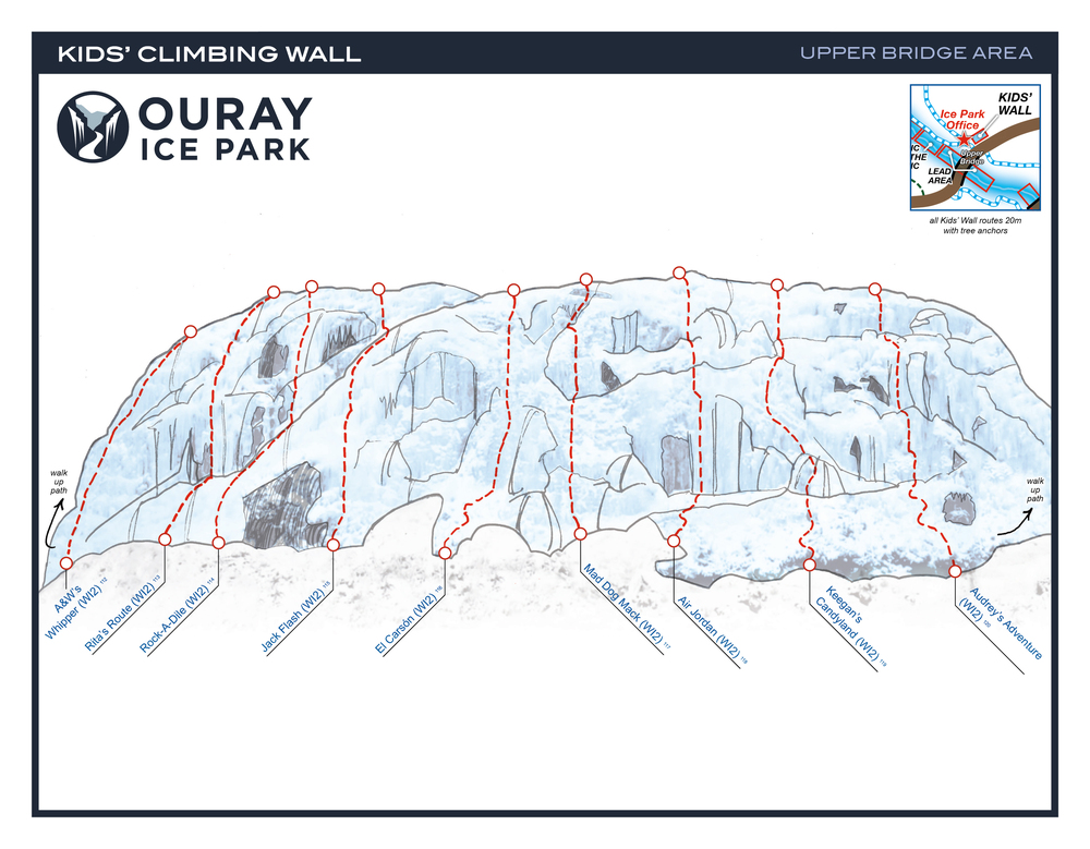
Kids Climbing Park: Grade Range: WI2, 9 Routes
Cette zone est juste à l’ouest du pont supérieur et pas dans la Gorge de Uncompahgre, avec des itinéraires de niveau débutant à intermédiaire, avec une Grange de WI2 de Grade.
January 18- 21, 2018
The Mountain Project Link
]]>
Ice Climbing: the Park offers excellent ice climbing form late December until into March. Routes range from WI4+- 6
Directions: north of Rifle on Highway 13, then east of Highway 325; continue past Rifle Gap and Rifle Falls State Parks, travel past the fish hatchery to the Park.
Fees: Daily Vehicle: $5 Annual Passes are offered from $15 to $50 depending on residence location. Camping: Including the Day Pass: $15 (camping fees are discounted with proof of annual pass.) The campground is currently dry, with water available at the Rifle Falls and Rifle Gap State Parks.
Rifle Mountain Park Routes:
[/cs_text][/cs_element_column][/cs_element_row][/cs_element_section][cs_element_section _id=”19″][cs_element_row _id=”20″][cs_element_column _id=”21″]
![]()