
Morrow Point Reservoir is downstream from Blue Mesa, the result of the construction of the Morrow Point dam. Access to Morrow Point is challenging due to the lack of road access. There are weekly boat tours, occurring twice daily from Memorial Day to Labor Day, reservations are required.
Crystal Reservoir was created in 1976 by the Bureau of Reclamation with three features, water storage, hydroelectric power, and public recreation. Crystal is part of the Curecanti NRA, is the least developed, most difficult to access, and the smallest of the three reservoirs. Crystal Reservoir is the last water storage unit before the Gunnison River enters the Black Canyon of the Gunnison.
[wpgmza id=”109″]
Activities:
- Boating (2 boat launches, personal watercraft prohibited)
- Fishing
- Fly Fishing
- Ice Fishing
- Horseback Riding
- Water Skiing
- Wind Surfing
- Camping (10 developed campgrounds)
- Boat-in Campsites
- Bird Watching
- Hiking
- Hunting
Curecanti National Recreation Area Park Map
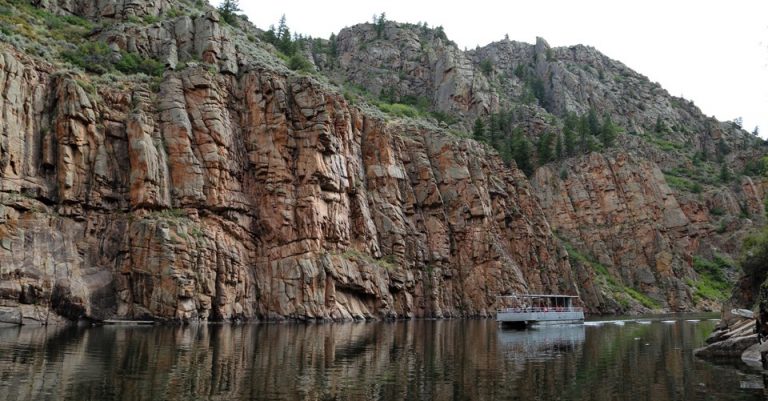
Morrow Point Boat Tour- Lisa Lynch
 ]]>
]]>


There are two major sites within the Monument, the Western Complex and the Lower House. The Western Complex is a "D" shaped pueblo with up to 600 rooms, 100 kivas, a tower, and a Great Kiva. This pueblo was constructed with adobe brick, starting at 1076 CE and finished by 1093 CE. The use of adobe brick was rare during the period. A fresh water spring runs through the middle of the site on a rise above the Lower House. The Lower House Pueblo is constructed in an "L" shape, with what is surmised as 8 lower floor rooms, a plaza with a Great Kiva, which is enclosed by a wall.
At the Monument there is no Visitor Center or facilities. The Monument is surrounded by private property on a dirt road, which can become a challenge during wet weather. Driving Directions (no signage on roads):
"From the intersection of Highway 160 and 191, travel south for approximately 8 miles; turn right on MC County Road B (green sign), a dirt road one mile south of MC Road C. Drive 0.8 miles, crossing paved road (MC Road 21); take the next dirt road to the right before the farmhouse on the left (As you make this turn, you will cross a yellow cattle guard and pass a "Box Bar Ranch, No Trespassing Sign." The sign does not apply to the County Road. Follow this road north and west for 1.4 miles, and head toward the white ranch house with the red roof on the west horizon. Once at the ranch house, Yucca National Monument is on the left side of the driveway. It is important to be courteous toward the private landowners and close all gates behind you as you enter to prevent livestock from escaping" Once at the parking area, follow the boardwalk and enter the monument through a small gate.
NPS Directions Link
Yucca House National Monument
C/O Mesa Verde National Park
970-529-4465
Yucca House National Monument
C/O Mesa Verde National Park
970-529-4465
Created by President Obama, on September 12, 2012, Chimney Rock National Monument consists of 4,726 acres in the San Juan National Forest of south central Colorado. The Monument preserves 200 ancient building sites of the Ancestral Puebloan people.
Chimney Rock's twin spires served as landmarks for both the Ancestral Puebloans and the Spanish who settled New Mexico in the 16th Centruy, CE. Four structures have been excavated, including a 44 foot diameter Great Kiva, the Pit House, a multi-room dwelling, and a Chacoan Great House Pueblo. Chimney Rock was a Pueblo II Community (900-1150 CE), some 70 miles away from the Chaco Canyon Area. Building construction techniques imitated the style and architectural features of Chaco buildings including Great Houses and Great Kivas. The Great House Pueblo has been dated from 1076 to 1093 CE, has 36 rooms and two kivas, with building material coming from the valley below. Both Chimney Rock Pueblo and the Lowry Ruin Pueblo are examples of Chaco Style architecture here in Colorado.se
Sesonal hours, open from May 15 until September 30 each year. Located 17 miles west of Pagosa Springs, and 40 miles east of Durango, the Monument is surrounded by the Southern Ute Indian Reservation.
It should be noted there is no Visitors Center or camping area within the National Monument.
Chimney Rock 2017 Brochure
(Chimney Rock Interpretative Association)
Chimney Rock National Monument Map
Use Restrictions (Seasonal) Map
Chimney Rock National Monument
3179 State Highway 151
Chimney Rock, CO
970-883-5359
Located in northwestern Colorado and eastern Utah, Dinosaur National Monument protects more than 800 paleontological sites. President Woodrow Wilson declared the monument on October 4, 1915. In 1938, the Monument expanded by over 200,000 acres to provide additional preservation and protection for the fossils.
Included in findings are Allosaurus, Apatosaurus, Camarasaurus, Diplodicus, and Stegosaurus. These fossils, as well as others, can be seen in the Quarry Building. A section of exposed Morrison Formation, enabled discoveries starting in 1909 by Earl Douglass, a paleontologist for the Carnegie Museum of Natural History.
The Quarry Building is located on the Utah section of the Monument near Jensen. The Quarry Building is the only exposed exhibit of fossils in the monument. Shuttle buses transport visitors to the Quarry Building from the Visitor Center during the busy spring through summer months. The Monument in the winter months groups visitors for transport to the Quarry Building on a schedule to facilitate the 45 minute quarry tour.
Activities: camping, backpacking and backcountry camping, bicycling, fishing, hiking, horseback riding, river rafting, stargazing.
Dinosaur National Monument has six camp grounds with 120 sites, with three campgrounds located in both states.
Green River: (4 miles east of the Quarry Visitor Center), 79 sites, flush toilets, water, no RV hookups or showers, open from April to the middle of October. Map
Split Mountain: (4 miles east of the Quarry Visitor Center) 4 group sites- check availablilty: (recreation.gov).
Rainbow Park: (28 miles from the Quarry Visitor Center), 4 sites for tent camping, vault toilets, no water Map
Echo Park: (38 miles north of Canyon Visitor Center), 22 sites, 1 group camping site, not suitable for RVs, water available during season, vault toilets. Map
Deer Lodge: (53 miles east of the Canyon Visitor Center) 7 walk in sites, tent camping, each site maximum of 25 campers, water during season, no RV hookups, vault toilets.
Gates of Lodore: (106 miles north of the Canyon Visitor Center) 19 sites for tents and RVs, no RV hookups, located on the Green River, vault toilets. Map
Fossil Discovery Trail (Quarry Visitor Center) Pdf
Dinosaur National Monument Hiking Trails Pdf
Park Pioneer: Josie Bassett Morris Pdf
Petroglyphs and Pictographs at Dinosaur National Monument Pdf
Petroglyphs and Pictographs Locations Map Pdf
Weed Warrior Program at Dinosaur National Monument Pdf
Guide to Important Fish Species at Dinosaur National Monument Pdf
Dinosaur National Monument
4545 Hwy 40
Dinosaur, UT
435-781-7700
The Black Canyon of the Gunnison National Park showcases a 12 mile section of the Gunnison River gorge. The Gunnison River drops an average of 34 feet per mile, the fifth steepest descent of a river in North America. The Gunnison Survey of 1853 provides the first governmental account of the canyon. By 1882 the Denver and Rio Grande Railroad conquered the canyon to Cimarron with the three foot narrow gauge line of rail. There is a railroad exhibit at Cimarron several miles east of the park on Highway 50. There are 3 entrances to the Park, both north and south rims. The total length of the Black Canyon is 53 miles, upstream is the Curecanti National Recreation Area, and downstream is the Gunnison Gorge National Conservation Area.
Location: 8 miles east of Montrose on Highway 50.
South Rim: open daily, with the South Rim Road being open from April to Mid November. During the winter the South Rim Road is open to Gunnison Point.
North Rim: the North Rim Road and ranger station are closed in the winter with the road closing from late November until mid-April.
Area: 48.05 Square Miles
South Rim Campground: The South Rim Campground is open year-round (Loop A only) with 88 campsites. There are electrical hookups available during the summer months on Loop B only. There are limited RV Services within the Park: no dump station, no showers, and vault toilets only.Elevation: 8,320 feet
North Rim Campground: seasonal camping on the North Rim from April to mid-November, 13 campsites, water available from late May to mid-September, no electrical hookups, no dump station, or showers, no flush toilets (vault toilets only).
Elevation: 7,783 feet
East Portal Campground: seasonal camping within the Curecanti National Recreation Area in the Black Canyon, 15 campsites, water is available only during the summer, no flush toilets (vault toilets) and no availability for RV’s (no vehicle in excess of 22 feet in total length, which includes a trailer, is allowed on the East Portal Road. The East Portal Road is steep at a 16% grade with sharp curves; the road is narrow.
Elevation: 6,526 feet.
Black Canyon of the Gunnison National Park Map
]]>
The high desert of the Colorado Plateau is fully exposed in the park, with sandstone canyons composed of sandstone layers of Entrada, Wingate and Kayenta. The Monument offers a condensed version of the country sandstone which is characteristic of the Plateau of Colorado, wide view on the sandstone of the Red rock, with deeply carved canyons with tower as formations. Rimrock Promenade runs along the numerous canyons in the Monument. This itinerary of Tour auto 23000 through the Monument offers visitors spectacular panoramas that serve to highlight the park, with 19 points of view along the road. The road runs along the four main canyons of the park, witnessing the erosion of the Uncompahgre Plateau.
A wide variety of wildlife can be seen in the Monument, including the Red-tailed hawk, Eagles, crows, jays, desert sheep and coyotes.
Location: Near the city of Grand Junction, Mesa County.
Area: 20, 533 acres.
Driving: West on Highway 70 direction Grand Junction, Exit 31 (Horizon Drive) east on Highway 70, use Exit 19 (Fruita) turn south on Route 340 to the west entrance. Montrose Highway 50 Follow Highway 50, which becomes Highway 6 & 50 at 1 St Street, VA on 1 St Street North Highway 340 (which is Broadway) west travel up to the entrance to the park.
Saddlehorn Campground Open all year round. The Canpground is the only campground established in the park, with 80 sites, sitting on a high cliff overlooking the Mesa Valley. Line A is open, your turn-first come, first served. Loop B is reservable via the Recreation.gov website or by calling 877-444-6777. Group Camping is available for 15 or more campers, make a reservation, call the Monument, 970-858-3617, x 300. In the Saddlehorn campsite, there are a limited number of jetty sites and an RV length restriction of 40 feet. There are no electrical connections or showers; Toilets have flush toilets being available during the summer season.
Activities: Camping, hiking, horseback riding, cycling on Rim Drive, Panoramics, the visitor Centre, a spectacular view of the Grand Valley, the Bookcliffs and the grand Mesa east of the road.
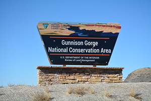
Fishing the Gold Medal Waters of the Gunnison River can be accomplished through trails taking one directly down to the Gorge and into the Wilderness Area. The wilderness area preserves 17,784 acres, with the primary activities of hiking, backpacking, fishing and floating on the Gunnison River. There are four major trails emanating from these access roads:
Chukar Road: 7 miles, trailhead for the Chukar Trail, 1.1 miles.
Bobcat Road: 1.5 miles, trailhead for the Bobcat Trail, 1.5 miles.
Duncan Road: 2.5 miles, trailhead for the Duncan Trail, 1.5 miles.
Ute Road: 2.5 miles, trailhead for the Ute Trail, 4.5 miles.
From Pleasure Park: North Fork to Smith Fork Trail, 4 miles.
The Gunnison Gorge National Conservation Area & Wilderness Area Brochure
Flat Top- Peach Valley OHV Brochure
Rafting in the Gunnison Gorge Wilderness Area:
Chuckar Trail to North Fork:
Season: Spring-Summer
Day-Use Pass: na
Class of Rapids: III
Length: 13.5 miles
Put-in: Chuckar Trail (1 mile from drop-off to Put-in on the Gunnison River.
American Whitewater.org
Hiking into the Gunnison Gorge Wilderness Area:
Chukar Trail:
Great views, Gold Medal Water with 1.1 mile trail down to the river. Chukar is the most heavily used trail in the NCA, with an elevations from 5,376 to 5,958 feet. Like many roads in Western Colorado, the Chukar invites one, with the last several miles being a progressively rougher four wheel drive road. As with all roads in the NCA, travel in wet weather is not advised. At the Trailhead there is a vault toilet, picnic tables with shade, and a visitor check-in and fee box.
Bobcat Trail:
A rough trail from the edge of the ridge down to the river. The last half mile of the Bobcat Trail is scrambling down cliffs to the river. This challenging route has an elevation difference from 5,529 to 6,249 feet.
Duncan Trail:
Trailhead is at the end of Duncan Road, with an elevation difference from 5,350 to 6,128 feet. The trail starts at a saddle on a ridge, with the view of the Uncompahgre Valley to the south and the Gorge to the north. From the trailhead, the distance to the river is 1.5 miles.
Ute Trail:
Ute Road is also listed as a four wheel drive route to the Trailhead. The Bobcat Trail is long and winding from the ridge into the gorge, with an elevation change from 5,369 to 6,512 feet. The distance from the ridge down to the river is 4.5 miles, with a trail along the river of over 3 miles in length. There are 4 designated hiker campsites. At the trailhead there is a vault toilet, shaded picnic table and grill, with a fee station with hiker registration.
North Fork to Smith Fork Trail:
 From Highway 92, between Austin and Hotchkiss, locate the Gunnison Gorge NCA sign, turn east on 28.10 Road to Pleasure Park. To access the North Fork to Smith Fork trail one must cross the North Fork of the Gunnison River and follow the trail east along the River for 4 miles of fishing access. At the trailhead there are vault toilets, picnic tables with shade, and cooking grills.
Check out our, “Ride The Gunnison Gorge NCA” page
Fishing the Gold Medal Water:
Gunnison River- elevation 5,058 feet
Fish: Brown Trout, Rainbow Trout
Access: Medium
Boating: Non-Motorized
Additional Info: From 5 miles above Austin (Relief Ditch Diversion) downstream to the confluence with the Colorado River in Grand Junction.
-No bag or possession limit for Channel Catfish, Largemouth Bass, Smallmouth Bass, Northern Pike, Walleye, Green Sunfish, Bluegill, Bullhead, Yellow Perch, or Crappie.
Flat Top- Peach Valley Recreation Area:
The Bureau of Land Management has designed special areas for OTV travel with out trail travel restrictions. At 9,700 acres, these recreation zones provide “play areas” for ATV, cross country motorcycles, and mountain bikes. Consisting of adobe hills and arroyos, as well as, juniper- pinon uplands, these “play areas” allow for un-restricted travel beyond a trail system.
]]>Basecamp Delta County Link
Recreation Areas:
Cactus Park:
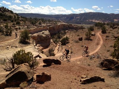
Activities: mountain biking, OHV riding on existing roads and trails, horseback riding, wildlife viewing and hiking. Access is by State Highway 141, the Cactus Park Road, and the Divide Road from the Uncompahgre Plateau. The 142 mile Tabeguache Mountain Bike Trail goes through Cactus Park. Cactus Park provides miles of trails and roads for motorized vehicles or mountain bikes. The Gunnison Gravels Area of Critical Environmental Concern preserves a gravel deposit whose physical characteristics provide evidence that the ancestral Gunnison River once flowed through Cactus Park and the Unaweep Canyon area.
Tabeguache Trail- Cactus Park Section:
Dominguez Canyon Wilderness Area:
Activities: (non-motorized travel) horseback riding, wildlife viewing and hiking. The main Big Dominguez Trail provides access to the scenic canyons and mesas in the wilderness area. The Dominguez Canyon WA includes streams, waterfalls, Native American rock art, historic structures from the heydays of mining, geologic features and wildlife. The easiest access point is at the Bridgeport Trailhead south of Highway 50. Turn on to the graveled Bridgeport Road for 3 miles down to the trailhead. There is a lower parking area which is mostly used for paddle access to the Gunnison River. There is a foot bridge for crossing the river with information kiosk before entering the gated wilderness area. Access to Little Dominguez Canyon is around 2.5 miles after entering through the gate. The upper end of Big Dominguez Canyon can be accessed from the Big Dominguez Campground, which is 11 miles off of Highway 141. The road to the Campground is gravel and not advisable for RVs or trailers. Camping by the river is limited to boaters with portable toilets. Backcountry camping is not permitted in the lower 5 miles of Big Dominguez Canyon and the lower 3 miles of Little Dominguez Canyon. There is a backpacking option for hiking both Big and Little Dominguez Canyons.
Hike Big Dominguez Canyon:
Escalante Canyon:
Activities: camping, hiking, access to Dominguez Canyon Wilderness Area, ATV driving on existing roads and trails, and picnicking. Escalante Canyon includes the Potholes Recreation Area, located 12 miles up the canyon on the gravel road. The recreation site has picnic tables, shade shelters and designated campsites. Be aware, swimming in the Potholes is dangerous, as there is a rotating water current that cannot be seen from the surface that is dangerous to swimmers. The Escalante Canyon Road provides vehicle access to historic cabins and trails in the rock walled canyon. There is Native American rock art, as well as historic inscriptions on canyon walls.
Dominguez- Escalante National Conservation Area Map
Dominguez- Escalante National Conservation Brochure
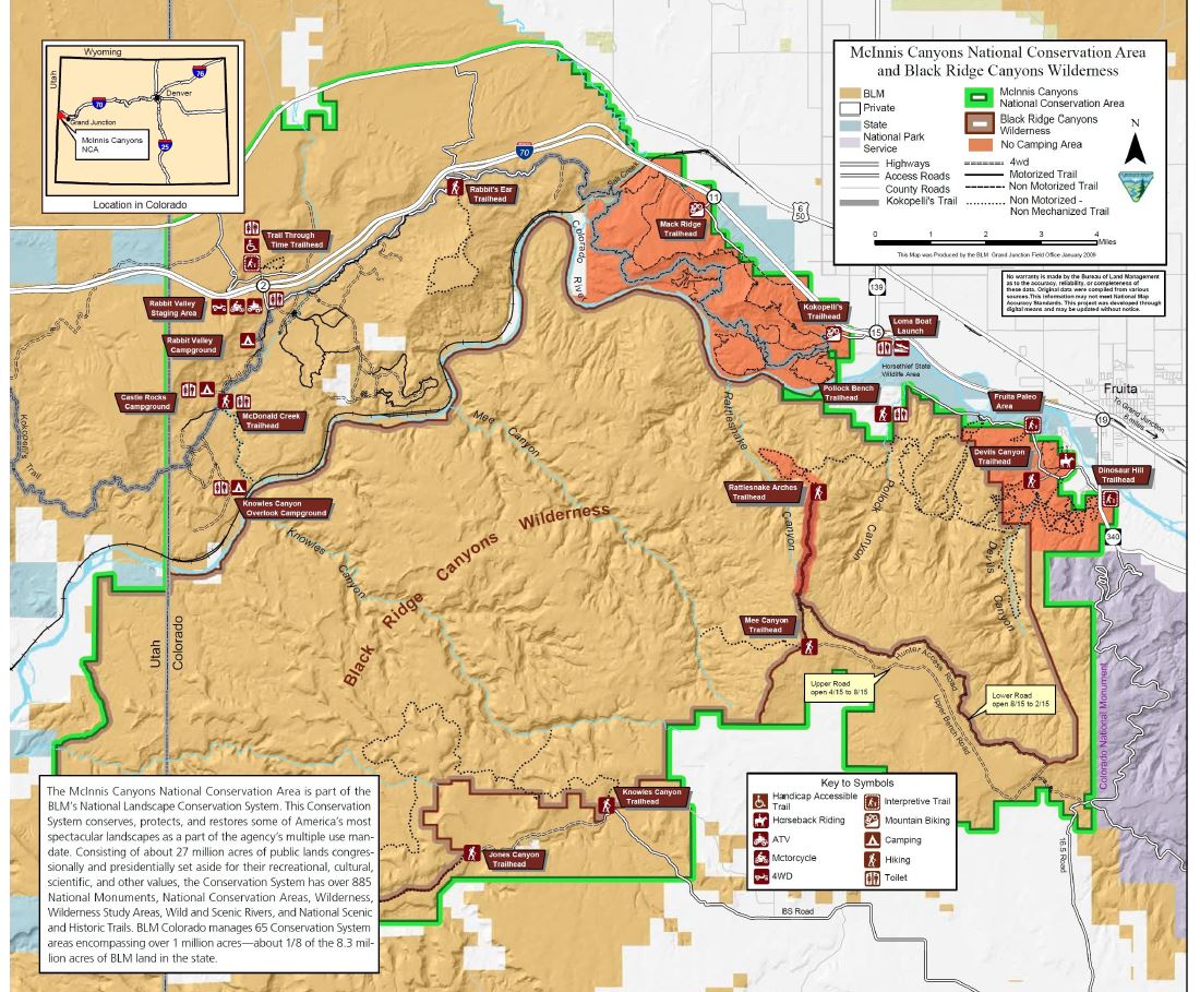
Located in western Mesa County and eastern Grand County in Utah, the McInnis Canyons National Conservation area has 123,400 acres, which includes 75,439 acres of the Black Ridge Canyons Wilderness Area. This NCA was designated on October 24, 2000 with the Colorado Canyons National Conservation Area and Black Ridge Canyons Wilderness Act (PL 106-353). The NCA was renamed after Congressman Scott McInnis on January 1, 2005.
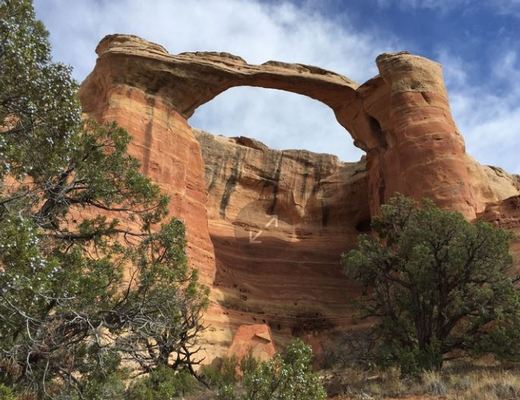
The Black Ridge Canyons Wilderness Area’s northern boundary is the Colorado River, which provides the easiest access to the wilderness area. The Black Ridge runs from east to west and is dissected by seven canyons. These canyons, with some reaching a depth of almost one thousand feet, have interesting geological features. With sandstone walls, the canyons are dotted with arches, spires, windows, and giant alcoves. Rattlesnake Canyon exhibits the largest concentration of natural arches in Colorado, second only to Arches National Park to the east in Utah. This wilderness area forms the core of the NCA, and is administered by the Bureau of Land Management.
McInnis Canyons National Conservation Area
Ride The Kokopelli Trail System:
 The Kokopelli Trail links the town of Fruita with Moab downstream in eastern Utah. The trail is about 140 miles in length and is a combination of single track, 4 X 4 double track, and rougher OHV trails. In the Fruita area, the Kokopelli Trail system is accessable at the Loma exit from I-70 west of Fruita. Continue Reading……
Paddle: McInnis Canyons
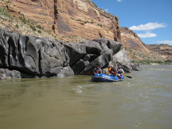 This section of the Colorado River (Loma Launch to Westwater) flows through the heart of the McInnis Canyons NCA. The run is approximately 25 miles in length with Class I & II rapids. There are many day hike opportunities in the side canyons of Knowles, Moore, Mee, Bull, and Rattlesnake. Continue Reading….
Hike: McInnis Canyons
 There are several sections of the McInnis Canyons NCA designed for hiking. Rabbit Valley, the Kokopelli Trail Area, and the Devils Canyon section have designated hiking trails. Continue Reading….
Cortez Basecamp Sponsors
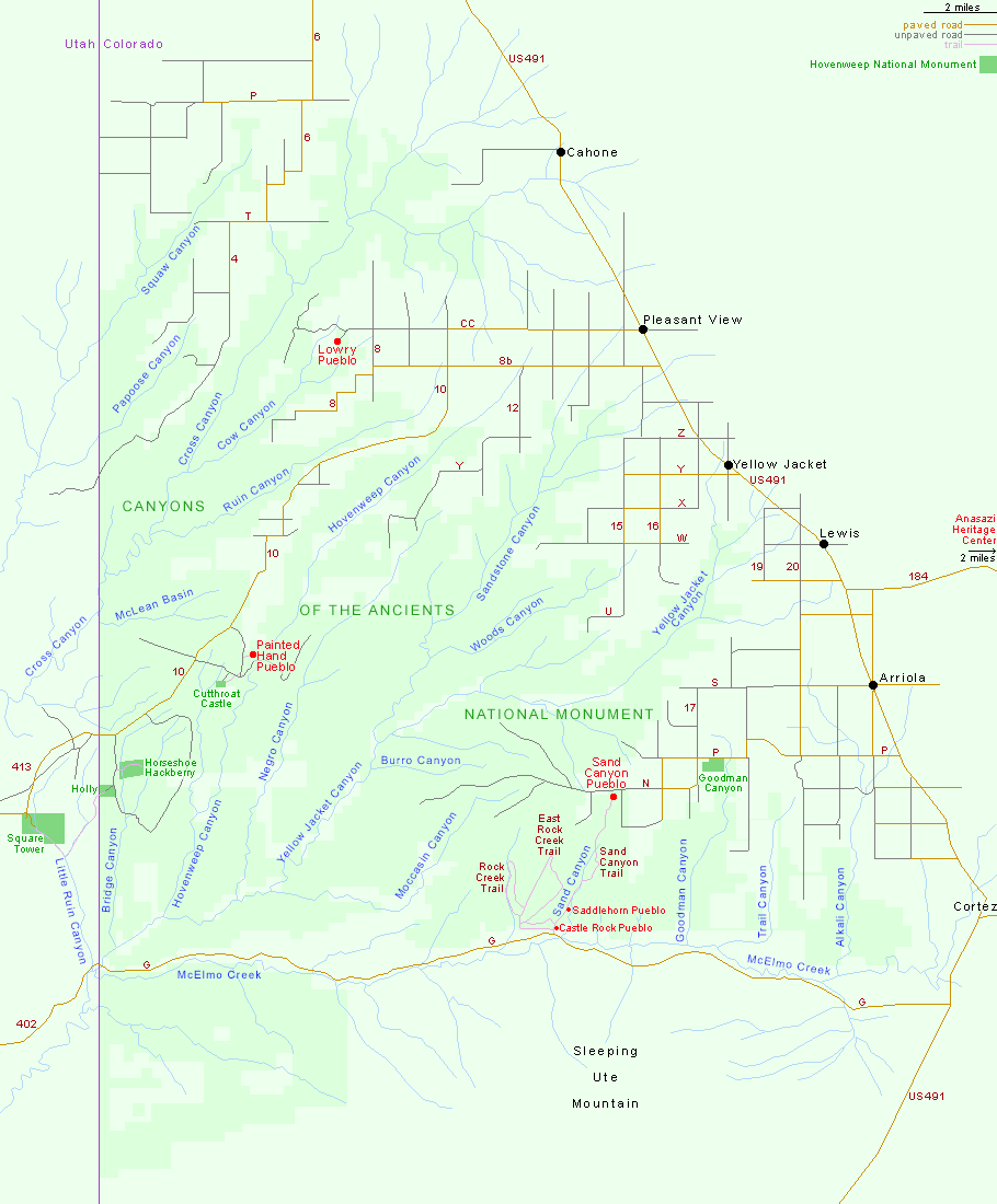
Canyons of the Ancients National Monument
(americansouthwest.net)
By the middle of the 8th century CE, the peoples called the Ancestral Puebloans moved into this area of south western Colorado. Beginning with clustered pit houses, which later evolved into above ground masonry dwellings, with connecting walls and south facing windows. Common dwelling shapes were "U," "E" and "L" shapes. In this developmental period, pottery became more diverse, bowls, jars, and table ware were created with black designs on a white background. There is evidence of water management and techniques to conserve water with the use of small reservoirs, check dams, and terrace construction. By the 14th Centruy CE, these native populations moved out of the region, south east into the Rio Grande Valley of New Mexico, and west into the high mesas of north eastern Arizona.
[wpgmza id="42"]
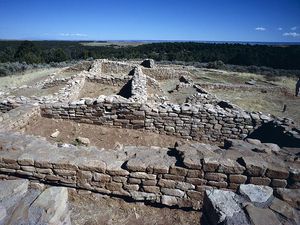 Lowry Pueblo: National Historic Landmark with 8 kivas, a great kiva, and 40 rooms built as high as three stories. The underground kiva has been dated around 1103, and due to it's size, is considered as a gathering place for religious ritual. The last occupation of the pueblo was in the early 13th century. This ruin was excavated from 1930 to 1936 by the Field Museum of Natural History of Chicago, by Paul S. Martin, and declared a National Historic Landmark on July 19, 1964. Today, Lowry Pueblo is part of the Canyons of the Nacients National Monument.
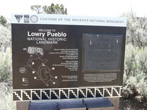 Lowry Pueblo is located off Highway 491 at Pleasant View, onto County Road CC, travel for 9 miles (14.5 Klm) to the west. The asphalt road turns to gravel and is passable by all vehicles. The Pueblo is the only developed recreation site within the Canyons of the Ancients, with interpretive signs, a picnic area, and pit toilet. There is no drinking water at the Lowry Pueblo, and no overnight camping.
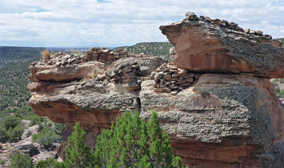
Painted Hand Pueblo
(americansouthwest.net)
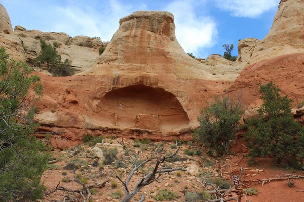 Saddle Horn Pueblo: located about a mile from the south trailhead. This cliff dwelling has two rooms located in the alcove and two structures on the "horn" about 100 feet above. Tree ring samples date the beams from 1228-1232, with pottery dating from 1250-1285 CE.