
USGS Topo maps link:
| Beaver Park | Little Cone | Gray Head |
| Groundhog Mountain | Dolores Peak | Mount Wilson |
Established: 1980
Acres: 41,309
Elevation Range: 9,000 to 14,246 feet
Peaks:
El Diente Peak- 14,316 feet
Wilson Peak- 14,017 feet
Mount Wilson- 14,246 feet
Towns: Telluride, Rico, Stoner, Dolores
Hunting Areas: 70
Links:
Camp: San Juan National Forest, Dolores RD
Camp: GMUG National Forest, Telluride
14er: San Juan Mountains, Lizard Head
Basecamp: Telluride
]]>Forest Service Wilderness Areas in Western Colorado:
Collegate Peaks Wilderness Area (White River, San Isabel, GMUG)
Eagles Nest Wilderness Area (White River)
Flat Tops Wilderness Area (Medicine Bow-Routt, White River)
Fossil Ridge Wilderness Area (GMUG)
Holy Cross Wilderness Area (San Isabel, White River)
Hunter-Frying Pan Wilderness Area (White River)
La Grata Wilderness Area (GMUG, Rio Grande)
Lizard Head Wilderness Area (San Juan, GMUG)
Maroon Bells- Snowmass Wilderness Area (GMUG, White River)
Mesa Verde Wilderness Area (San Juan)
Mount Sneffels Wilderness Area (GMUG)
Mount Zirkel Wilderness Area (Medicine Bow-Routt)
Never Summer Wilderness Area (Arapaho, Medicine Bow-Routt)
Platt River Wilderness Area (Medicine Bow-Routt)
Raggeds Wilderness Area (GMUG, White River)
Sarvis Creek Wilderness Area (Medicine Bow-Routt)
South San Juan Wilderness Area (Rio Grande, San Juan)
Uncompahgre (Big Blue) Wilderness Area (GMUG)
Weminuche Wilderness Area (San Juan, Rio Grande)
West Elk Wilderness Area (GMUG)
Bureau of Land Management Wilderness Areas:
Black Ridge Wilderness Area
Gunnison Gorge Wilderness Area
Dominguez Canyon Wilderness Area
National Park Service:
Black Canyon of the Gunnison National Park
Canyons of the Ancients National Monument
Colorado National Monument
Hovenweep National Monument
Mesa Verde National Park
]]>
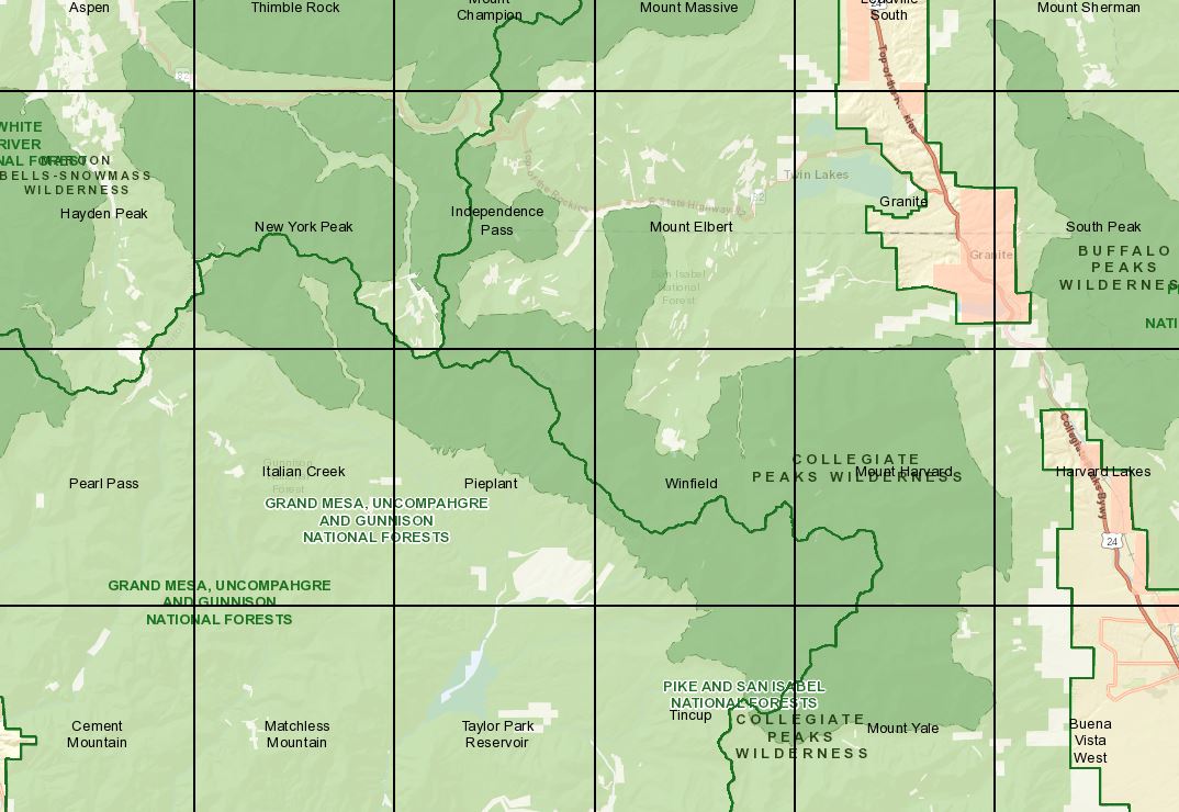
USGS Topo Maps Link:
| Tincup | Mount Yale | Winfield |
| Mount Harvard | Pieplant | Italian Creek |
| Hayden Peak | New York Peak | Independence Pass |
| Mount Elbert | Aspen |
Established: 1978
Acres: 132,906
Elevation Range: 7,850 to 13,534 feet
Peaks:
La Plata Peak- 14,340 feet
Missouri Mountain- 14,067 feet
Mount Harvard- 14,420 feet
Mount Belford- 14,197 feet
Huron Peak- 14,005 feet
Mount Princeton- 14,196 feet
Mount Oxford- 14,153 feet
Mount Yale- 14,196 feet
Mount Columbia- 14,073
Towns: Leadville, Buena Vista, Aspen, Crested Butte, Salida
Hunting Areas: 471, 48, 481, 55
Trail Heads:
Trailhead at the end of Taylor Park Road (CR 742)
Bowman Creek Trail #570
Dorchester Campground/ Forest Road #584
New York Creek Trail #2182 (White River NF)
Ptarmigan Lake trail #594
Trailhead at Pothole Reservoir:
Timberline Trail #414
Red Mountain Creek Trail # 543 (area is unavailable)
Texas Creek Trailhead:
Timberline Trail # 414,
Lake Ann Trail #592
Texas Creek Trail #416
Cottonwood Pass:
South Texas Creek # 417
Collegiate Peaks Trailhead (San Isabel NF)
North Denny Creek #1442
Links:
]]>
USGS Topo Maps Link:
| Red Cliff | Vail Pass | Frisco |
| Vail East | Willow Lakes | Dillon |
Established: 1978
Acres: 132,906
Elevation Range: 7,850 to 13,534 feet
Peaks:
Towns: Dillon, Frisco, Vail
Hunting Areas: 36, 371, 45, 37
Links:
]]>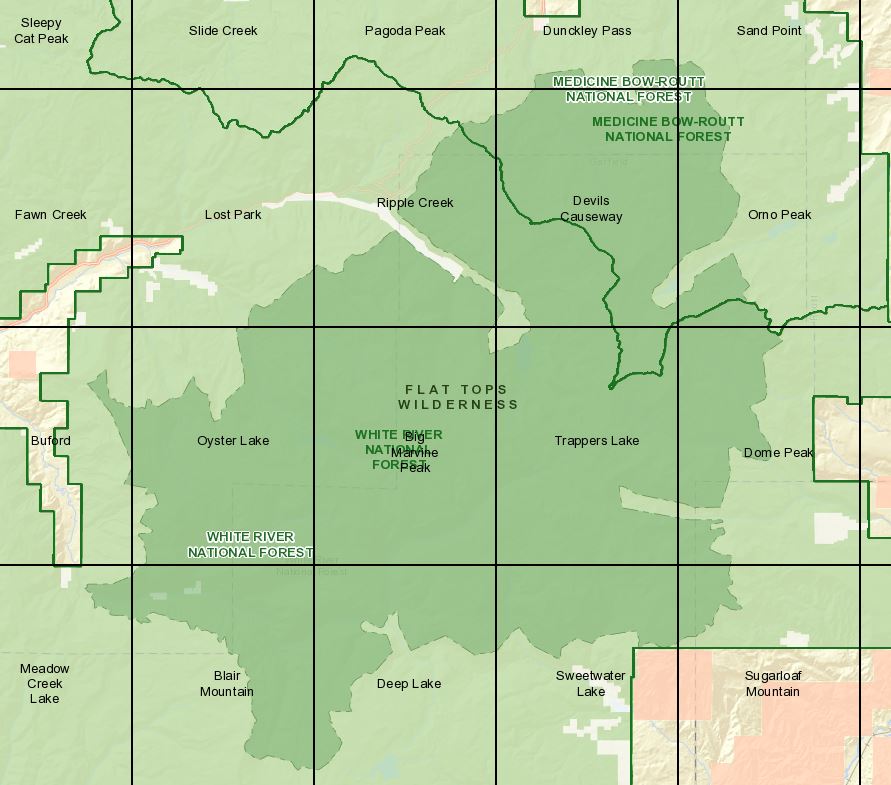
USGS Topo Maps Link:
Established: 1975
Acres: 235,035
Elevation Range: 7,600 to 12,994 feet
Peaks:
Towns: Rifle, Meeker, Yampa, Steamboat Springs, Oak Creek, Hayden
Hunting Areas: 24, 25, 12, 26, 33, 34
Links:
Camp: Medicine Bow-Routt National Forest, Gore Range-Flat Tops Area
]]>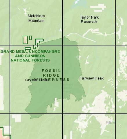
USGA Topo Maps Link:
| Crystal Creek | Fairview Peak | Parlin |
| Pitkin | Matchless Mountain | Taylor Park Reservoir |
Established: 1993
Acres: 31,534
Elevation Range: 9,000 to 13,254 feet
Peaks:
Henry Mountain- 13, 261 feet
Towns:
Gunnison, Crested Butte
Hunting Areas: 55
Links:
Camp: GMUG National Forest, Gunnison RD
Basecamp Gunnison Link
]]>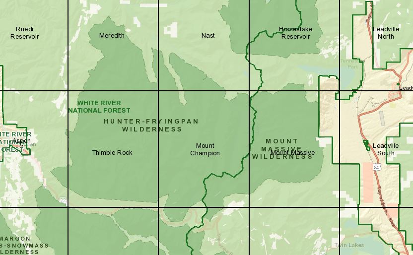
USGS Topo Maps link:
| Independence Pass | Aspen | Thimble Rock |
| Mount Champion | Mount Massive |
Established: 1978
Acres: 82,026
Elevation Range: 9,000 to 13,000 feet
Peaks:
Hunting Areas: 47, 48
Links:
]]>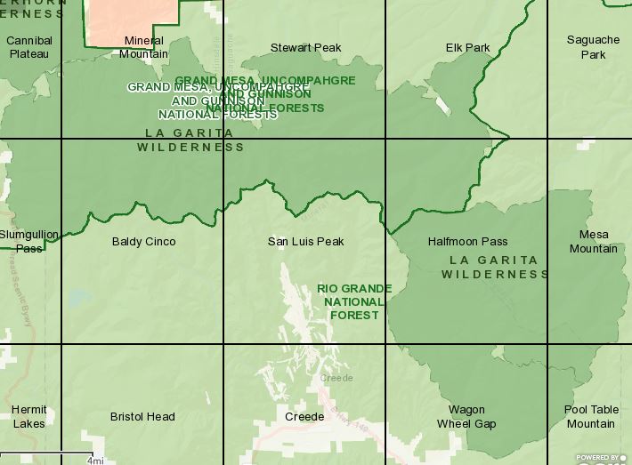
USGS Topo Maps Link:
| Cannibal Plateau | Mineral Mountain | Stewart Peak | Elk Park |
| Slumgullion Pass | Baldy Cinco | San Luis Peak | Halfmoon Pass |
| Mesa Mountain | Wagon Wheel Gap | Pool Table Mountain |
Established: 1964
Acres: 128,858
Elevation Range: 9,000 to 14,014 feet
Peaks:
San Luis Peak- 14,014 feet
Stewart Peak- 13,9838 feet
Phoenix Peak- 13.895 feet
Organ Mountain- 13,801 feet
La Garita Peak- 13,710 feet
Baldy Alto- 13,698 feet
Towns: Creed, Lake City, South Fork, Powderhorn, Gunnison
Hunting Areas: 66, 67, 681, 76
]]>For information on the Maroon Bells-Snowmass Wilderness contact the U.S. Forest service at 970-925-3445 or visit www.fs.fed.us/r2/whiteriver/recreation/wilderness/maroonbells/index
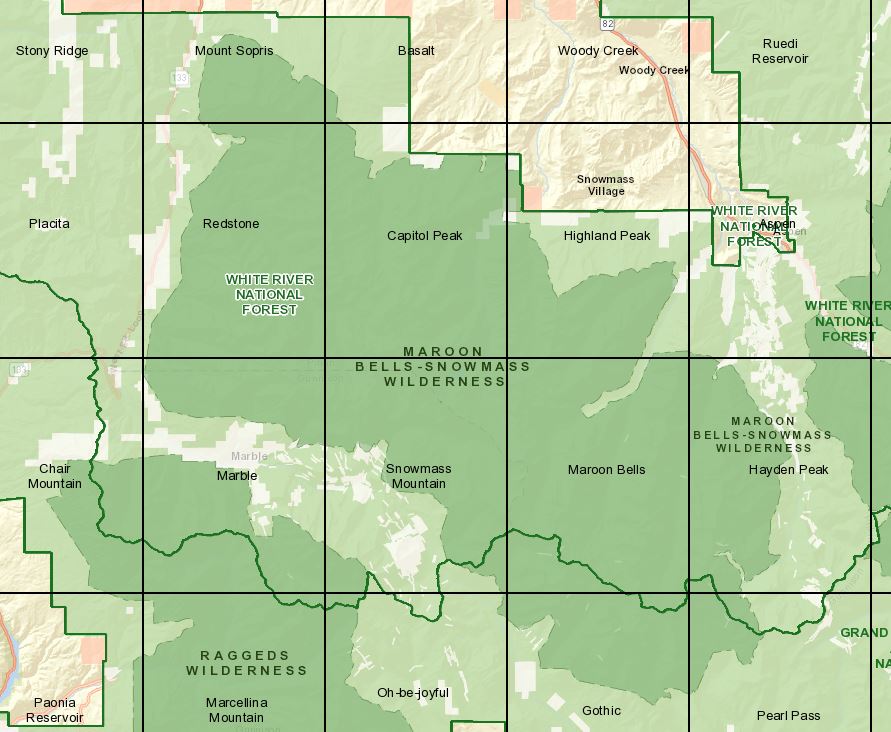
USGS Topo Maps Link:
| Gothic | Pearl Pass | Snowmass Mountain | Maroon Bells |
| Hayden Peak | Marble | Redstone | Capitol Peak |
| Highland Peak | Mount Sopris | Basalt |
Established: 1964 (one of the five original Wilderness Areas in Colorado)
Acres: 181,535
Elevation Range: 7,500 to 14,265 feet
Peaks:
Towns: Aspen, Snowmass, Woody Creek, Basalt, El Jebel, Carbondale, Glenwood Springs
Links:
]]>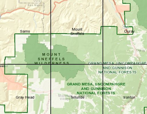
USGS Topo Maps Link:
| Sams | Mount Sneffels | Gray Head | Telluride |
Established: 1980
Acres: 16,565
Elevation Range: 9,600 to 14,150 feet
Peaks: Mount Sneffels- 14,150 feet
Towns:
Ridgway
Ouray
Telluride
Hunting Areas: 61, 65
Links:
Camp: GMUG National Forest, Ouray RD
]]>