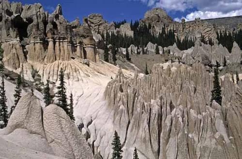
Located in the La Garita Mountains, this 129,626 was one of the original five Wilderness Areas in Colorado. Like the San Juan Mountains to the west, the La Garitata Mountains consist of multiple layers of volcanic rock. Columnar Basalt can be seen on lower elevations of Stewart and San Luis Peaks. Pictured is the Wheeler Geologic Area, accessed with the East Bellows Trail or a good 4WD. This rock formation is similar to Bryce Canyon in Utah, the result of ash flow deposits 25-30 million years ago. The Wilderness Area serves as a primary head water for the Rio Grande River which flows into the Gulf of Mexico. The Area straddles the continental divide and sits both on the West and Eastern Slopes of Colorado. One of the most scenic sections of the Colorado Trail passes through the Area being above timberline. Little traffic in the La Garita Wilderness Area supports good hunting for those willing to hike or pack in during hunting season.
USGS Topo Maps Link:
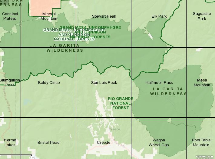
| Cannibal Plateau | Mineral Mountain | Stewart Peak | Elk Park |
| Slumgullion Pass | Baldy Cinco | San Luis Peak | Halfmoon Pass |
| Mesa Mountain | Wagon Wheel Gap | Pool Table Mountain |
Established: 1964
Acres: 128,858
Elevation Range: 9,000 to 14,014 feet
Peaks:
San Luis Peak- 14,014 feet
Stewart Peak- 13,9838 feet
Phoenix Peak- 13.895 feet
Organ Mountain- 13,801 feet
La Garita Peak- 13,710 feet
Baldy Alto- 13,698 feet
Towns: Creed, Lake City, South Fork, Powderhorn, Gunnison
Hunting Areas: 66, 67, 681, 76