
[wpgmza id=”90″]
San Miguel River |
Dolores River |
|---|---|
| Pinon Bridge to Naturita: Season: Spring- Summer Day Use Pass: na Class of Rapids: I (IV- Varies with level) Length: na Put-in: Pinon Bridge American Whitewater.org |
Slickrock to Bedrock: Season: Spring-Summer Day-Use Pass: na Class of Rapids: II-III Length: 50 miles Put-in: Slickrock Bridge American Whitewater.org |
| Naturita to Dolores Confluence: Season: Spring- Summer Day Use Pass: na Class of Rapids: Length: miles Put-in: Naturita American Whitewater.org |
Bedrock to Gateway (Paradox and Mesa Canyon): Season: Spring-Summer Day-Use Pass: na Class of Rapids: II-III Length: 50 miles Put-in: Bedrock Launch Site American Whitewater.org |
| Gateway to Colorado River: Season: Spring-Summer Day-Use Pass: na Class of Rapids: II & IV Length: 30 miles Put-in: Gateway American Whitewater.org |
|
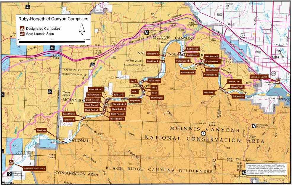
This section of the Colorado River (Loma Launch to Westwater) flows through the heart of the McInnis Canyons NCA. The run is approximately 25 miles in length with Class I & II rapids. There are many day hike opportunities in the side canyons of Knowles, Moore, Mee, Bull, and Rattlesnake.
Day use permits are not required for paddling on this section of the river. There are overnight camping permits required, with low impact camping, and no fires are allowed in the river corridor, as of July 1, 2017. Beginning on May 1, 2017, reservation fees (recreation.gov) have increased from $6 to $10.
Basecamp Fruita Link
Bureau of Land Management
Grand Junction Field Office
2815 H Road
Grand Junction, CO 81506
River Permit Phone: (970) 244-3000
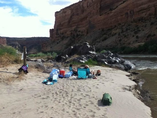
Ruby-Horsethief Campsites:
Ruby Horsethief Canyons from Mara Ferris on Vimeo.
With two reservoirs, the Dillon and Green Mountain Reservoirs provide hydroelectric power, as well as, water storage. The Blue meets the Colorado River at Kremmling in north central Colorado.
*The Breckenridge Whitewater Park consists of 10 features, offering training for first time and beginners.
[wpgmza id=”55″]
| Breckenridge Town Run (Breck Whitewater Park*): Season: Spring- Summer Day Use Pass: na Class of Rapids: Length: miles Put-in: American Whitewater.org |
|
| Blue River Campground to Columbine Landing (Upper Blue): Season: Spring- Summer Day Use Pass: na Class of Rapids: III-IV Length: 3 miles Put-in: American Whitewater.org Green Mountain Reservoir to Spring Creek Road (Green Mountain Canyon): Season: Spring- Summer Day Use Pass: na Class of Rapids: III Length: 3.8 miles Put-in: American Whitewater.org |
|
Blue River Below Green Mountain
|
|
Marble, incorporated 1889, below Crystal is known for the high quality marble that was used in parts of the Lincoln Memorial and the Tomb of the Unknowns in Washington, D.C. Marble was discovered in the late 1870’s, further developed in 1905, with production drawing down in 1941 at the beginning of World War II. Currently marble is being quarried, with the operations being closed to the public.
[wpgmza id=”57″]
| Crystal River, North Fork to Scree Slope:
Season: Spring- Summer |
Schofield Pass to Crystal:
Season: Spring- Summer |
| Crystal Mil Falls to Crystal Gorge:
Season: Spring- Summer |
Road to Crystal to Beaver Lake:
Season: Spring- Summer |
| Marble to Redstone:
Season: Spring- Summer |
Redstone to Penny Hot Springs:
Season: Spring- Summer |
| Penny Hot Springs to Avalanche Creek (Narrows):
Season: Spring- Summer |
Avalanche Creek to BRB Campground:
Season: Spring- Summer |
Crystal River ABV Avalanche Creek
- Temperature: 37.76 ° F
- Streamflow: 237 ft³/s
- Gage height: 1.51 ft
[wpgmza id=”56″]
| Weller Lake to Difficult Camp Ground (Upper Roaring Fork): Season: Spring- Summer Day Use Pass: na Class of Rapids: V+ Length: 3.2 miles Put-in: Weller Lake AmericanWhitewater.org |
Slaughterhouse Aspen to Woody Creek Bridge: Season: Spring- Summer Day Use Pass: na Class of Rapids: IV-V Length: 4.5 miles Put-in: Aspen American Whitewater.org |
| Upper Woody Creek Bridge to Lower Woody Creek Bridge: Season: Spring- Summer Day Use Pass: na Class of Rapids: III Length: 3.8 miles Put-in: Upper Woody Creek Bridge American Whitewater.org |
Lower Woody Creek Bridge to Route 82 Bridge: Season: Spring- Summer Day Use Pass: na Class of Rapids: III Length: 6.2 miles Put-in: Lower Woody Creek Bridge American Whitewater.org |
| Black Bridge to Veltus Park (Cemetery): Season: Spring- Summer Day Use Pass: na Class of Rapids: II+ Length: 6.2 miles Put-in: Black Bridge American Whitewater.org |
|
Roaring Fork Above Difficult CG
|
|
Roaring Fork at Glenwood Springs
|
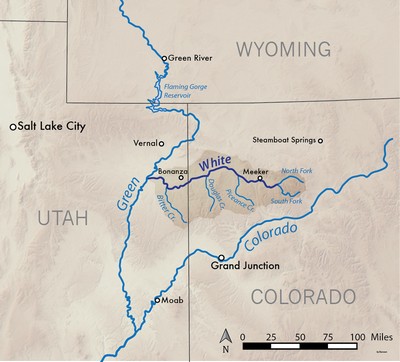
White River, Wikipedia.org
The White River in north central Colorado is a tributary of the Green River, which flows into the Colorado at Moab, Utah. Starting in the Flat Tops Wilderness Area in northeastern Garfield County, the White stretches for 195 miles. The North Fork of the White starts at Wall Lake and flows northwest, then southwest. The South Fork rises about 10 miles south of the North Fork, and meets near Buford, forming the White River proper.[wpgmza id=”61″]
| North Fork, White River:
Season: Spring- Summer |
South Fork, White River:
Season: Spring- Summer |
| South Fork, White River:
Season: Spring- Summer |
|
White River Above Coal Creek Near Meeker, Co
|
White River Below Boise Creek, Near Rangely, Co
|
The first section of the Elk River below the Seedhouse Campground is the Box Canyon run with Class V-V+ drops for it’s first 1.8 miles. This little canyon, with it’s sheer walls has an adverage depth of 30 feet. Once past the Box Canyon portion, the Elk mellows out for twenty plus miles of Class III water until it meets the Yampa River.
[wpgmza id=”62″]
| Elk River- Box Canyon Season: Spring-Fall Day Use Pass: na Class of Rapids: V Length: 1.3 miles Put-in: Below Seedhouse Campground (confluence of Middle Fork Elk River) American Whitewater.org |
Seedhouse Campground to Glen Eden Bridge Season: Spring- Fall Day Use Pass: na Class of Rapids: III- V+ Length: 8 miles Put-in: same as above American Whitewater.org |
| Two miles above Mad Creek to Mad Creek: Season: Spring- Fall Day Use Pass: na Class of Rapids: I-II Length: 2 miles Put-in: 2 miles above Mad Creek American Whitewater.org |
[wpgmza id=”63″]
| Yampa River Park to Transit Center: Season: Spring-Fall Day Use Pass: na Class of Rapids: III Length: 3 miles Put-in: 209 River Road, Steamboat Springs American Whitewater.org |
Transit Center to Pump Station: Season: Spring-Fall Day Use Pass: na Class of Rapids: I Length: na Put-in: Transit Center American Whitewater.org |
| Little Yampa Canyon: Season: Spring-Fall Day Use Pass: na Class of Rapids: I-III Length: 50 miles Put-in: Hwy 13 South of Craig American Whitewater.org |
85 Road to Deer Park Lodge Road: Season: Spring-Fall Day Use Pass: na Class of Rapids: IV-V Length: na Put-in: 85 Road, Maybell, CO American Whitewater.org |
| Deer Lodge to Echo Park: Season: Spring-Fall Day Use Pass: na Class of Rapids: II-IV Length: 46 miles Put-in: Deer Lodge American Whitewater.org |
|
Yampa Ruver at Steanboat Springs
|
|
Yampa River Above Elkhead Creek Near Hayden, Co
|
River Manager 1:
Yampa River State Park
6185 West US 40
Hayden, CO 81639
970-276-2061
River Manager 2:
Bureau of Land Management
Little Snake Field Office
455 Emerson Street
Craig, CO 81625
970-826-5000
[wpgmza id=”60″]
East River: Season: Spring- Summer |
|
Slate River: Season: Spring- Summer |
Beaver Ponds to Oh Be Joyful CG: Season: Spring- Summer |
| Oh Be Joyful Creek:
Season: Spring- Summer |
|
East River below Cement Creek Nr Crested Butte, CO
|
Major Tributaries of the Colorado:
Frazier River
Muddy Creek
Blue River– Snake River, Tenmile Creek
Eagle River- Gore Creek
Roaring Fork River– Fryingpan River, Crystal River
Gunnison River– East River (Slate Creek), Taylor River, Uncompahgre River
Dolores River– San Miguel River
Green River- Yampa River (Elk River, White River)
San Juan River- Navajo River, Piedra River, Animas River,
[wpgmza id=”53″]
Colorado River Section: UtahHot Sulphur Springs to Hwy 40 bridge (Byers Canyon): Season: Spring-Summer |
Gore Canyon:
Season: Spring-Summer |
| Pumphouse Campground to State Bridge (Pumphouse):
Season: Spring-Summer |
State Bridge to Burns: Season: Spring-Summer |
Burns to Dotsero (Burns Canyon): Season: Spring-Summer |
Hanging Lake to Shoshone Power Plant:
Season: Spring-Summer |
| Shoshone Power Plant to Grizzly Creek: Season: Spring-Summer Day-Use Pass: na Class of Rapids: III-IV Length: 2 miles Put-in: Shoshone Power Plant, Exit 125 American Whitewater.org |
Grizzly Creek to Two Rivers Park: Season: Spring-Summer |
| Two Rivers Park to South Canyon: Season: Spring-Summer Day-Use Pass: na Class of Rapids: II Length: 6 miles Put-in: Grizzly Creek American Whitewater.org |
South Canyon to New Castle: Season: Spring-Summer Day-Use Pass: na Class of Rapids: I Length: 9.4 miles Put-in: Two Rivers Park American Whitewater.org |
| New Castle to Cameo: Season: Spring-Summer Day-Use Pass: na Class of Rapids: I Length: na Put-in: New Castle American Whitewater.org |
Big Sur: Season: Spring-Summer Day-Use Pass: na Class of Rapids: III Length: 0.1 miles Put-in: Cameo “Big Sur on the Colorado is a unique feature that occurs when flows reach 20,000cfs. High flows are provided by coordinated reservoir operations upstream, and are intended to support endangered fish in the Grand Valley. ” American Whitewater.org |
| Grand Junction Town (Palisade to Loma Launch: Season: Spring-Summer |
|
Colorado River Section: UtahColorado River, Loma launch to Westwater launch (Ruby to Horsetheif): |
Westwater launch to Rose Ranch (Westwater Canyon): Season: Spring- Summer Day Use Pass: na Class of Rapids: I-IV Length: 17 miles Put-in: Westwater American Whitewater.org |
| Cisco (Rose Ranch) to Moab: Season: Spring- Summer Day Use Pass: na Class of Rapids: I-III Length: 47 miles Put-in: Rose Ranch American Whitewater.org |
Confluence with Green River to Lake Powell: Season: Spring- Summer Day Use Pass: na Class of Rapids: I-IV Length: 112 miles Put-in: Confluence of the GreenAmerican Whitewater.org |
Colorado River Below Baker Gulch Nr Grand Lake
|
|
Colorado River At Windy Gap, Near Granby
|
Colorado River Below Glenwood Springs
|
Colo River Below Grand Valley Div Nr Palisade
|
|
Colorado River At Catamount Bridge
|
Colorado River Near Colorado- Utah State Line
|