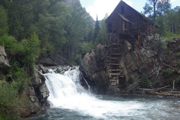
Born in northern Gunnison County and flowing north west, the Crystal River moving through the old mining town of Crystal, Marble, Redstone, and finally into the Roaring Fork near Carbondale. The upper Crystal River flows between two wilderness areas, the Raggeds to the south and the Maroon Bells- Snowmass to the north. Mining in the area was for silver, copper, zinc, lead, and iron. The Crystal Mill-1892 (next to the Falls) is one of the most photographed historic sites in Colorado. Above the town-site, the road becomes one of the more dangerous four-wheel drive roads in the State.
Marble, incorporated 1889, below Crystal is known for the high quality marble that was used in parts of the Lincoln Memorial and the Tomb of the Unknowns in Washington, D.C. Marble was discovered in the late 1870’s, further developed in 1905, with production drawing down in 1941 at the beginning of World War II. Currently marble is being quarried, with the operations being closed to the public.
 Crystal River to Scree Slope
American Whitewater.org
To Scree Slope Rapid 1
American Whitewater.org
To Scree Slope, Rapid 2
American Whitewater.org
To Scree Slope, Rapid 3
American Whitewater.org
To Scree Slope, Rapid 3
American Whitewater.org
To Scree Slope
American Whitewater.org
Crystal Mill & Falls
American Whitewater.org
Crystal Mill Falls
American Whitewater.org
Pine Tree Falls
above Marble
American Whitewater.org
Steep & Bony Fall
American Whitewater.org
End of Gorge above Marble
American Whitewater.org
Marble to Redstone: Bogan Canyon
American Whitewater.org
Bogan Canyon
American Whitewater.org
Meat Grinder, Redstone to Penny HS
American Whitewater.org
Meat Grinder, Redstone to Penny HS
American Whitewater.org
Penny Hot Springs
5280.com
Crystal River to Scree Slope
American Whitewater.org
To Scree Slope Rapid 1
American Whitewater.org
To Scree Slope, Rapid 2
American Whitewater.org
To Scree Slope, Rapid 3
American Whitewater.org
To Scree Slope, Rapid 3
American Whitewater.org
To Scree Slope
American Whitewater.org
Crystal Mill & Falls
American Whitewater.org
Crystal Mill Falls
American Whitewater.org
Pine Tree Falls
above Marble
American Whitewater.org
Steep & Bony Fall
American Whitewater.org
End of Gorge above Marble
American Whitewater.org
Marble to Redstone: Bogan Canyon
American Whitewater.org
Bogan Canyon
American Whitewater.org
Meat Grinder, Redstone to Penny HS
American Whitewater.org
Meat Grinder, Redstone to Penny HS
American Whitewater.org
Penny Hot Springs
5280.com
[wpgmza id=”57″]
| Crystal River, North Fork to Scree Slope:
Season: Spring- Summer
Day Use Pass: na
Class of Rapids: V+
Length: 0.65 miles
Put-in: North Fork Crystal
American Whitewater.org |
Schofield Pass to Crystal:
Season: Spring- Summer
Day Use Pass: na
Class of Rapids: V+
Length: 0.25 miles
Put-in: Below Schofield Pass
American Whitewater.org |
| Crystal Mil Falls to Crystal Gorge:
Season: Spring- Summer
Day Use Pass: na
Class of Rapids: III-IV
Length: 3 miles
Put-in: Crystal Mill Falls
American Whitewater.org |
Road to Crystal to Beaver Lake:
Season: Spring- Summer
Day Use Pass: na
Class of Rapids: V+
Length: 1.8 miles
Put-in: Above Marble
American Whitewater.org |
| Marble to Redstone:
Season: Spring- Summer
Day Use Pass: na
Class of Rapids: III-IV
Length: 3 miles
Put-in: Marbke
American Whitewater.org
|
Redstone to Penny Hot Springs:
Season: Spring- Summer
Day Use Pass: na
Class of Rapids: V+
Length: 2 miles
Put-in: Redstone
American Whitewater.org |
| Penny Hot Springs to Avalanche Creek (Narrows):
Season: Spring- Summer
Day Use Pass: na
Class of Rapids: IV-V
Length: 2.1 miles
Put-in: Penny Hot Springs
American Whitewater.org
|
Avalanche Creek to BRB Campground:
Season: Spring- Summer
Day Use Pass: na
Class of Rapids: III
Length: 4.8 miles
Put-in: Avalanche Creek
American Whitewater.org
|
- Streamflow: 165 ft³/s
- Gage height: 1.27 ft
USGS