This post is also available in:  English
 Français
 Deutsch
 日本語
日本語
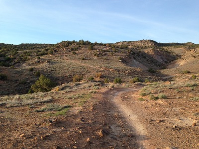
Ride: Tabeguache Trail
The Tabeguache (TAB-a-watch) Trail stretches from the Shavano Valley, trail head about 9 miles from downtown Montrose to the No Thoroughfare Canyon at the Colorado National Monument just outside of Grand Junction. The trail is over 140 miles in length and takes several days to complete. Most of the trail is not maintained or patrolled by the BLM or USFS, resulting in rider preparation before hitting the trail head. Be advised of adverse conditions due to season and weather can make the trail impassible. During hunting season it is strongly advised to wear blaze orange jackets and head coverings.
Grand Junction Trail Head: From North 1st in downtown Grand Junction take State Highway 340 (Broadway Avenue) west to Monument Road (major intersection) going left on Monument Road follow toward the National Monument with the trail head on the left just past Mariposa Drive. From Montrose at Main and Townsend Avenue follow West Main Street west, staying on West Main when it becomes Spring Creek Boulevard, continue west to the top of Spring Creek (past the Highway 90 turn at the top of the hill) about 4 miles until the intersection with with 5875 Road. Take 5875 Road out several miles until the “T” intersection with Kiowa Road and go left of Kiowa Road. Follow across Shavano Valley until meeting Shavano Valley Road and go left, the Montrose Trail Head is at the intersection of Rim Road and Shavano Valley Road.
[wunderground location=”Montrose, CO” numdays=”4″ layout=”simple”]
Resources: