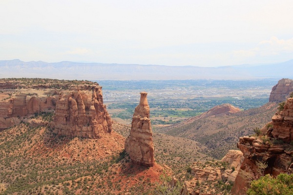
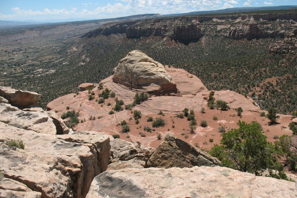
モニュメントキャニオンのトレイル出発は、公園の西側入口から東へ約2.1マイルのHwy 340のすぐそばにあります。 キャニオンモニュメントの下部には、岩層の素晴らしい景色が見えます。 登山者は公園のハイキング規則を知る必要があります:動物は登山道には許可されておらず、斜面には車両や自転車はなく、痕跡が残らず、すべてのごみを報告し、野生動物を観察してください。 すべてのバックカントリーのキャンパーは、キャンプの前にビジターセンターで無料の許可証を取得する必要があります。 USGS Topo Maps Link: Colorado National Monument Grand Junction Clifton Glade Park Island Mesa Whitewater Basecamp Grand Junction Link Monument Canyon Trail Head: Monument Canyon and Wedding Canyon: Monument Canyon Trail: …
Hike: The Grand Valley- White Rocks
ワイルドウッド トレイル ヘッドは 6.5 マイルの西の入り口をハイウェイ 340 から公園の西の入口の東に位置、南ブロードウェイ/レッドランズ パークウェイの光をオンにします。ワイルドウッド ドライブに南ブロードウェイで 1.2 キロを左折、駐車場は道路の右側にある 800 メートル。 ハイカーはハイキング公園のルールを知るべきである: ペット同伴コース上ない車両やバイク トレイル、残してないの追跡およびレポートすべてのゴミ、距離から野生動物を観察します。バックカントリー キャンプは、キャンプ前にビジター センターで無料の許可証を取得しなければなりません。 USGS Topo Maps Link: Colorado National Monument Grand Junction Clifton Glade Park Island Mesa Whitewater Basecamp Grand Junction Link …
Hike: The Grand Valley
壮大な川 (コロラド州)、グランド バレー機関の名前は、30 マイルの長さと幅 5 キロです。Uncompahgre の高原は南と北に本崖、渓谷は、野外活動の複数の場所を提供しています。ハイキング、ロード ・ マウンテン バイク、乗馬、登山、子供用プール、屋外活動の最初。コロラド川谷を柵に入ると、ガニソン川ミッド バレーと西の砂岩の峡谷を介して状態を終了する応答します。 西側斜面で最大の都市、グランド ジャンクションは、アウトドア愛好家のための優秀なサポート サービスを提供しています。「フルータの小さな町は、小さくなり柵故郷を提供」を感じるグランド ジャンクションの大きい都市の。 ハイキングのこのセクションは谷の東です。 USGS Topo Maps Link: Colorado National Monument Grand Junction Clifton Glade Park Island Mesa Whitewater Basecamp Grand Junction Link Basecamp …
Hike: The Grand Valley- Redlands
東公園の入り口 (ブロードウェイ、入り口に記念碑の道にである州ハイウェイ 340) のすぐ内側東口コースがあります。蛇の道は、公園に最初の道として建設されました。 向上、いいえ大通りキャニオンの景色の 770 フィート以上 1.75 マイル、このトレイルつづら折りのストレッチ。 ハイカーは基本的な公園ハイキング規制注意すべき: ペット同伴のハイキング コース、車や歩道、自転車を後ろに痕跡とすべてのゴミ、距離でのワイルド ライフをパック残さない。任意のバックカントリー キャンプは、キャンプ前に公園のビジター センターで無料の許可証を取得しなければなりません。 USGS Topo Maps Link: Colorado National Monument Grand Junction Clifton Glade Park Island Mesa Whitewater Basecamp Grand Junction Link コロラド国定公園: 東入口コース: Serpents Trail: …
Hike: The Grand Valley- Redlands
The East Entrance trails are located just inside the Eastern Park Entrance (State Hwy 340 which is Broadway, to Monument Road to the Entrance). The Serpents Trail was built as the first road into the Park. Stretching for 1.75 miles, …
Hike: The Grand Valley- White Rocks
The Wildwood Trail Head is located east of the Western Entrance to the Park, From the west entrance take State Hwy 340 for 6.5 miles, turning at the light to South Broadway/Redlands Parkway. At 1.2 miles on South Broadway, turn …
Hike: The Grand Valley- Monument Canyon
The Trail Head for the Monument Canyon is located just off of State Hwy 340, about 2.1 miles east of the West Park Entrance. The lower part of Monument Canyon offers excellent views of towering rock formations. Hikers should be …
Hike: The Grand Valley
Named for the Grand (Colorado) River, the Grand Valley is about 30 miles long and 5 miles wide. With the Uncompahgre Plateau to the south and the Book Cliff Range to the north, the valley provides multiple venues for outdoor …